Venice’s Ponte della Libertà is the result of two separate engineering revolutions. The railway bridge across the lagoon opened on January 11, 1846, under Austrian rule. The neighboring road bridge opened on April 25, 1933, as Ponte Littorio and was renamed Ponte della Libertà in 1946. Today the approximately 3.85-kilometer (2.39-mile) corridor carries trains, cars, buses, and trams toward a historic city where ordinary road traffic must stop. This is the story from the first rail crossing to the present day.
The bridge is really two bridges
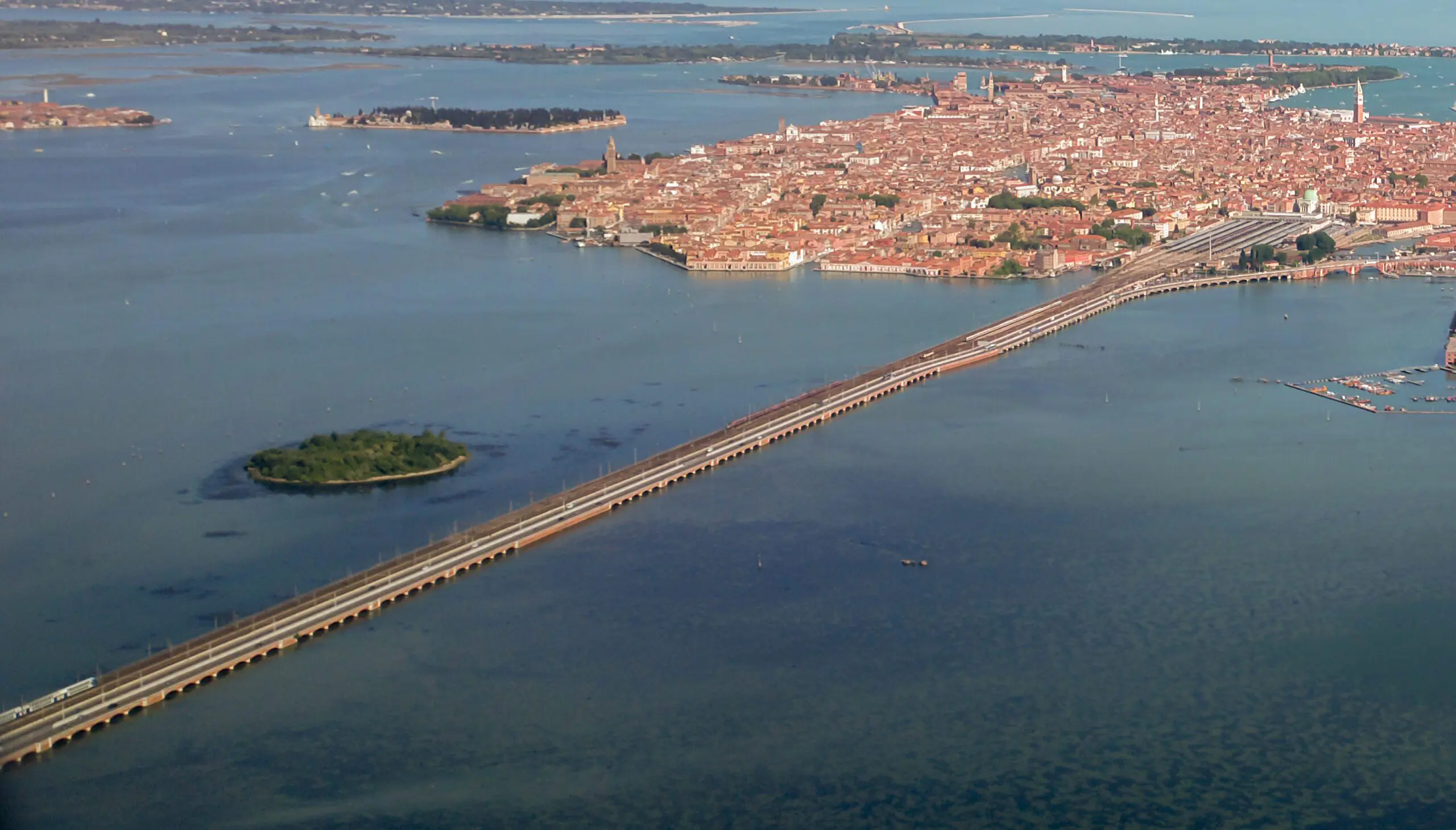
The familiar four-kilometer approach to Venice is not a single structure built at one moment. It consists of a nineteenth-century railway viaduct and a twentieth-century road bridge standing side by side. The railway crossing opened in 1846; the road crossing opened in 1933. Together they transformed how people, supplies, and ideas moved between the historic islands and the mainland.
That distinction is the key to the entire story. When people say Ponte della Libertà, they usually mean the roadway, but the adjacent railway is older by almost ninety years. The two crossings represent different revolutions: steam-age rail travel and the age of automobiles, buses, and eventually trams.
Before 1846: an island city reached by water
For centuries, Venice depended on boats for connections across its lagoon. Travelers arriving from the mainland could not simply drive or ride a train directly to the historic islands. The city was a maritime capital whose roads were canals, and its commercial and political life was organized around water transport.
That arrangement shaped the experience of arrival. The lagoon was not an incidental obstacle but a protective landscape and a defining element of Venetian identity. Constructing a permanent rail connection therefore meant more than reducing travel time. It changed the relationship between Venice and the mainland, making the city part of a modern terrestrial transport network.
The Austrian era and the railway ambition
In the early nineteenth century, Venice belonged to the Austrian-ruled Kingdom of Lombardy-Venetia. The railway project connecting Milan and Venice was commonly known as the Ferdinandea, after Emperor Ferdinand. Industrial-era planners saw railways as tools for trade, administration, and the movement of passengers across the region.
A rail viaduct over the lagoon was an extraordinary undertaking for its period. Engineers had to address soft lagoon ground, tidal water, and a long exposed route. The project symbolized a new kind of connectivity, but it also marked a decisive break with the older pattern in which arrival at Venice was fundamentally a journey by boat.
1846: the first permanent crossing opens
The lagoon railway bridge was inaugurated on January 11, 1846. It carried trains across approximately 3.85 kilometers of lagoon, linking the mainland with Venice. The crossing became part of the railway network serving the city and fundamentally altered how travelers could arrive.
The inauguration date is worth remembering because the road bridge did not yet exist. For almost nine decades, the railway provided the principal fixed connection across the lagoon. Visitors arriving by train were participating in a modern experience, while the historic center itself continued to function without conventional road traffic.
What the railway bridge looked like
The original railway crossing was a long viaduct of repeated arches. Its scale is difficult to appreciate from a train window because the sequence of arches and water seems to continue almost indefinitely. Viewed from the lagoon, the repetitive masonry form expresses the engineering logic of the nineteenth century.
The structure is a useful reminder that Venice is not preserved in a single historical moment. Its survival has always required construction, repair, and adaptation. The railway viaduct is part of that story, even though tourists more often photograph gondolas and palaces than the infrastructure bringing them into the city.
1848–1849: the bridge and the revolution
Only two years after the railway bridge opened, revolution erupted in Venice. During the 1848–1849 struggle against Austrian rule, the fixed connection became strategically important. Transport infrastructure that had promised commercial integration could also influence military operations and the city’s defense.
The history of the 1849 siege demonstrates that a bridge can be both a convenience and a vulnerability. The lagoon had long helped protect Venice; a permanent connection changed the strategic geography. The memorial visible near the route recalls the conflict and the people who died, a story easily missed by passengers watching the skyline.
The memorial beside the crossing
A little-known detail on the lagoon approach is the memorial associated with the 1849 defense of Venice. Italy’s official tourism portal describes a column, intertwined branches, and two historic cannons oriented toward the mainland. The monument links the modern transport corridor to a moment of political struggle.
Travelers who cross the lagoon at speed rarely have time to identify it. Yet this is precisely the kind of detail that reveals how different historical periods overlap. The same stretch of water witnessed imperial railway ambition, republican resistance, and the later expansion of the modern city.
After unification: Venice enters a new national network
Venice joined the Kingdom of Italy in 1866. By then, railways were becoming central to national movement and economic life. The lagoon bridge connected Venice to a network extending well beyond the Veneto, making arrival by train increasingly ordinary.
The city still retained its distinctive internal geography. Trains could reach the edge of the historic islands, but passengers continued onward on foot or by boat. This pattern established a division that remains visible today: the mainland uses conventional vehicles, while the heart of Venice relies on walking and waterborne transport.
The railway station and the new western gateway
As railway travel developed, the western edge of Venice became an increasingly important arrival zone. The modern Santa Lucia station stands where the rail line reaches the islands. Its location changed the hierarchy of entrances to a city once approached primarily from the lagoon and maritime routes.
For travelers, the station creates an immediate contrast. A long train journey ends at a building opening onto water, steps, boats, and pedestrian streets. The railway brought Venice closer to the rest of Europe without making the historic center resemble an ordinary road-based city.
Industrial Mestre and Porto Marghera
During the late nineteenth and early twentieth centuries, the mainland around Mestre and Marghera changed dramatically. Industrial development, new port facilities, and expanding road networks created demand for a stronger connection to the historic city. The railway alone no longer answered every transport need.
The emergence of Porto Marghera was particularly important. Venice was becoming a wider metropolitan and industrial system rather than only an island historic center. A road bridge fitted into that broader transformation, linking employment, commerce, and urban expansion across the lagoon.
Why a road bridge was proposed
By the 1920s, automobiles and buses were becoming increasingly important in Italy. Venice’s lack of a direct road connection was seen by planners as a practical constraint. The proposed bridge would let vehicles reach a terminal at the western edge of the islands, even though they would not enter the pedestrian historic center.
This distinction matters. The goal was not to fill Venice’s narrow calli with cars. It was to create a controlled meeting point between mainland roads and the city’s unique pedestrian and canal network. Piazzale Roma would become that meeting point.
The early design and Vittorio Umberto Fantucci
The road bridge’s design history is more complicated than the simplified claim that one engineer invented it alone. Research and historical accounts identify earlier proposals, including work by engineer Vittorio Umberto Fantucci. Eugenio Miozzi later revised and directed the project that was actually built.
Recognizing the earlier work does not diminish Miozzi’s role. It makes the chronology more accurate. Major public infrastructure usually emerges from several stages of proposals, revisions, administrative decisions, and construction expertise. The bridge is a product of that process, not an isolated sketch.
Eugenio Miozzi arrives in Venice
Eugenio Miozzi became head of Venice’s municipal technical office in 1930. He would leave a profound mark on the city’s infrastructure, including the road bridge, Piazzale Roma, and other works intended to modernize movement while operating within a historic urban setting.
Miozzi was not designing a single object detached from its surroundings. His work involved coordinating roads, garages, canals, bridges, and public spaces. That systems approach helps explain why the road bridge and its terminal should be understood as one large urban project.
1931: construction of the road bridge begins
Construction of the roadway began in July 1931. It was placed alongside the existing railway viaduct, taking advantage of an established crossing corridor. The project moved quickly for its scale, with the new connection completed in less than two years.
The speed reflected both engineering organization and the political context. Italy’s Fascist government promoted major public works as demonstrations of modernization and national strength. Historical accuracy requires acknowledging that context rather than treating the project as an apolitical achievement.
The Fascist-era name: Ponte Littorio
When the road bridge opened, it was called Ponte Littorio. The name referred to the fasces, a symbol used by the Fascist regime. It expressed the political identity of the state sponsoring the project, not the neutral name familiar to travelers today.
Names are historical evidence. The original title reveals how infrastructure was used to communicate political messages in the 1930s. After the Second World War, the bridge would receive a different name, reflecting the end of the dictatorship and a new national narrative.
April 25, 1933: inauguration day
The road bridge was inaugurated on April 25, 1933, a date that already had special significance in Venice because it is the feast of St. Mark, the city’s patron saint. Contemporary accounts identify the participation of Crown Prince Umberto, Maria José, and Benito Mussolini.
The ceremony presented the bridge as a major modernization of the city. The date acquired a striking second meaning after the war, when April 25 became Italy’s national Liberation Day. The same calendar day thus connects Venice’s patron saint, a Fascist-era public work, and the later commemoration of liberation.
A bridge about 3.85 kilometers long
The road crossing measures approximately 3,850 meters, or 2.39 miles. Its long, low route creates an unusual experience: the driver moves between expanses of lagoon water while the historic city gradually approaches. The railway follows beside it.
Those measurements help visitors understand why the bridge is more than an ordinary urban overpass. It is a major causeway-like connection over a tidal environment, exposed to weather and dependent on continuous maintenance. It is also the principal roadway link to the historic city’s western vehicle terminal.
Piazzale Roma: where cars must stop
The road bridge ends at Piazzale Roma, the vehicle gateway to historic Venice. From here, travelers continue on foot, by vaporetto, or by private boat. The bridge did not create streets for cars throughout the historic center; it created a terminal at its edge.
That arrangement remains central to travel planning. A taxi can take you to Piazzale Roma, but most hotels deeper in Venice require an additional walking or water transfer. Visitors who assume a car can reach their hotel door misunderstand the original purpose of the bridge.
The municipal garage and the arrival system
The road project was accompanied by the creation of a large municipal parking garage at Piazzale Roma. Archival material describes a facility designed for roughly 1,700 vehicles indoors, with additional capacity on the roof. It was an ambitious component of the new transport terminal.
The garage demonstrates that the bridge was part of a broader urban transformation. Engineers needed a place for vehicles to stop, passengers to transfer, and traffic to circulate. Without that terminal, the bridge would have delivered cars to a city unable to absorb them.
Rio Novo and the water connection onward
Another related intervention was the development of Rio Novo, intended to improve water connections between the new western gateway and central Venice. This reveals the hybrid thinking behind the project: road traffic would reach the edge of the city, and boats would continue the journey.
The bridge therefore did not replace Venice’s waterways. It made the coordination between land transport and water transport more important. That relationship is still visible whenever travelers transfer from a bus or taxi at Piazzale Roma to a vaporetto or private water taxi.
The Second World War and changing political meanings
The 1930s infrastructure entered a radically different political era during the Second World War. Italy’s dictatorship collapsed, the country experienced occupation and conflict, and the meaning of public monuments and names was reconsidered.
The road bridge survived as essential infrastructure, but its original political name became unacceptable in the new national context. Its renaming was part of a wider process of removing overt Fascist references from public spaces and reframing them for postwar Italy.
1946: Ponte della Libertà
In 1946, the road bridge was renamed Ponte della Libertà, or Liberty Bridge, to commemorate liberation from Fascism and Nazi occupation. The new name replaced the explicitly Fascist Ponte Littorio. It remains the name used today.
The renaming is not a minor footnote. It tells visitors that public infrastructure carries political memory as well as traffic. The same structure can serve successive governments and generations while its official identity changes to reflect new values.
The postwar mainland grows
After the war, the mainland districts of Mestre and Marghera expanded. More residents worked, studied, and traveled across the lagoon, increasing pressure on both rail and road links. The bridge became a daily commuting corridor rather than merely a symbolic arrival route.
This shift changed how Venetians experienced the connection. For tourists, the crossing might be a memorable first view of the lagoon. For commuters, it became part of ordinary life, with all the practical concerns of timetables, congestion, maintenance, and weather.
The railway expands beyond two tracks
The nineteenth-century railway viaduct was originally designed for two tracks. In the twentieth century, growing demand led to widening and reconstruction to accommodate four tracks. The expansion took place over several stages rather than in one overnight change.
Historical accounts record the activation of new tracks in November 1978, followed by work on the older structure, and full four-track operation by 1984. The details matter because the railway bridge visible today is not simply the untouched 1846 original. It is a historic infrastructure corridor that has been adapted repeatedly.
1978 to 1984: a new railway capacity
The expansion of the rail crossing made it possible to handle more trains between the mainland and Santa Lucia. The new tracks were brought into service in 1978, while older sections were subsequently rehabilitated. Full four-track operation was achieved in 1984 according to historical accounts.
This phase illustrates a recurring theme: Venice does not preserve its transport infrastructure by refusing change. It preserves the city by adapting essential systems to contemporary needs. Railway upgrades are less photogenic than historic palaces, but they influence how millions of visitors and residents reach the lagoon.
Tronchetto and the changing road terminal
As car travel increased, the island of Tronchetto developed as an additional parking and transport area near the western edge of Venice. The road connection and associated ramps made it possible to direct vehicles to parking rather than push them into the historic center.
Today, travelers may see signs for Piazzale Roma or Tronchetto and assume they are the same place. They are not. Both are connected to the road arrival system, but their parking, transport, and transfer arrangements differ. Knowing which one you need can save a frustrating detour.
The tram joins the crossing
In the twenty-first century, Venice’s modern tram network extended its service toward Piazzale Roma. Tram service between Mestre and Venice began operating over the bridge in 2015, adding another form of public transport to the roadway corridor.
This development completed an interesting circle. The first fixed crossing was built for rail in the nineteenth century; the road bridge followed in the twentieth; and modern rail-based urban transport later began sharing the road approach. The crossing remains a place where different eras of transport technology meet.
Buses, cars, trams, and trains side by side
Seen from above, the two bridges reveal Venice’s dependence on a concentrated western transport corridor. Trains use the rail viaduct; buses, cars, and trams use the road connection. The historic islands begin where these systems hand passengers over to walking and boats.
This concentration makes the crossing essential and sometimes vulnerable to disruption. Traffic incidents, maintenance work, or severe weather can affect access. Visitors should consult current transport notices rather than assume that every service runs unchanged. The bridge is infrastructure, not simply a scenic road.
Walking and cycling: what travelers should know
The road bridge includes a pedestrian and cycling route on its southern side, but the experience is not comparable to a relaxed stroll through Venice’s historic streets. It is a long, exposed crossing near traffic, and weather conditions can make it uncomfortable.
Travelers should check current access arrangements and local regulations before setting out, especially if using a bicycle. Venice’s historic center has strict rules affecting cycling and pedestrian areas. For most visitors arriving with luggage, the train or public transport is more practical than walking the full lagoon crossing.
Why the lagoon crossing feels different by train
The view from a train approaching Santa Lucia can be one of the most memorable introductions to Venice. Water stretches out beside the tracks, small islands appear, and the skyline emerges gradually. The experience is distinct from arriving by road because the train ends directly at the station beside the Grand Canal.
For travelers, this is a rare example of infrastructure shaping an emotional first impression. A utilitarian viaduct becomes the frame through which the city reveals itself. The moment is worth appreciating even if you have made the journey many times.
What road travelers see
Drivers and bus passengers experience the lagoon from a different angle, with the parallel railway bridge and broad water views accompanying the approach. The route leads toward Piazzale Roma or Tronchetto, where the journey changes from wheels to feet or boats.
The practical lesson is to plan that change in advance. If your hotel is on an inner canal, a road transfer alone may not be enough. Confirm where you will leave the vehicle and how you will continue. Venice’s unusual geography begins before you reach your accommodation.
The bridge’s maintenance challenges
A long structure exposed to salt air, wind, traffic, and lagoon conditions requires regular maintenance. The rail and road bridges are not static relics. They are working pieces of infrastructure whose condition and operating arrangements must be managed continuously.
It would be irresponsible to claim a specific repair schedule or closure without checking current official notices. Travelers should use the relevant rail, road, and municipal channels for live information. The historical story explains why the bridge exists; real-time transport updates determine how to use it today.
A local detail visitors usually miss
One of the most revealing facts is that the road bridge did not eliminate Venice’s dependence on boats. It created a new point where boats became necessary again. At Piazzale Roma, a traveler can step off a modern bus and still need a water taxi to reach a hotel just a short distance away on the map.
This is a useful lesson from Igor Scomparin’s experience as a licensed Venice guide since 1997: the last part of a journey can be more complicated than the long drive across the lagoon. Bridge access, boat landings, hotel entrances, luggage, and tides all affect a realistic transfer plan.
The relationship with Calatrava’s bridge
The Ponte della Libertà and the Ponte della Costituzione serve different purposes. The former connects the mainland to Venice; the latter, designed by Santiago Calatrava and opened in 2008, crosses the Grand Canal between Piazzale Roma and the station area.
They belong to the same wider transport story. The nineteenth-century railway and twentieth-century road bridges brought passengers to neighboring arrival points. The twenty-first-century pedestrian bridge was intended to make movement between those points easier, though it generated its own controversies over accessibility and materials.
Three complementary readings
To understand why the road bridge stops at the edge of the historic center, read why Venice has no cars. For the workers and logistics that keep the city operating, explore how Venice works before sunrise.
To see how the city reveals its history through overlooked infrastructure and details, visit ten hidden details that tell Venice’s real story. These three published articles complement the chronology of the lagoon crossings without duplicating its main subject.
What the bridge means today
In 2026, Ponte della Libertà remains the essential road gateway to historic Venice, while the railway viaduct beside it continues carrying trains to Santa Lucia. Together they embody nearly two centuries of transformation, from Austrian-era rail engineering to Fascist-era road construction, postwar renaming, rail expansion, and modern tram service.
The bridge is more than a strip of asphalt across the water. It marks the boundary between two ways of moving: the mainland’s trains and vehicles and the historic city’s pedestrian streets and canals. Understanding that boundary helps visitors appreciate why Venice is both connected to modern Europe and unlike any ordinary European city.
Historical sources and photo credit
The official Italian tourism portal confirms the 1846 and 1933 openings, the wartime history, and the 1946 name. Research from the University of Padua documents Eugenio Miozzi’s urban infrastructure program. The Italian national architecture archives describe Piazzale Roma’s garage, and the IUAV University of Venice archive contains historic construction photographs. Featured image: real aerial photograph showing the road and railway crossings side by side, Wikimedia Commons; the image is not a reconstruction.
Explore the wider story
For related perspectives, discover how Venice was built; Venice’s many types of boats; the history of wooden bridges. These articles add historical and practical context to this subject.
Frequently Asked Questions
When was the first bridge connecting Venice to the mainland built?
The first permanent railway viaduct across the Venetian Lagoon opened on January 11, 1846, under Austrian rule, almost ninety years before the neighboring road bridge.
When did Venice get a bridge for cars, and why was it renamed?
The road bridge opened on April 25, 1933, as Ponte Littorio during the Fascist era. It was renamed Ponte della Libertà in 1946 to commemorate liberation from Fascism and Nazi occupation.
Can you drive across Ponte della Libertà into central Venice?
You can drive across the lagoon to the western vehicle terminals, principally Piazzale Roma and the Tronchetto area, but cars cannot continue into most of Venice’s historic center. Travelers proceed on foot or by water transport.