Is climate change putting Venice at risk? Yes. Scientists have strong evidence that global sea level is rising, and Venice faces increasing long-term pressure from relative sea-level change. But the exact future water level, frequency of extreme flooding, and effectiveness of adaptation depend on several uncertain factors. MOSE can reduce some high-water impacts; it does not stop sea-level rise. This evidence-based guide separates established science from projections, unresolved questions, and misleading headlines.
The city in the water, and the questions science can answer
Venice has lived with water for centuries, but climate change alters the baseline against which familiar tides and storms operate. Scientists can measure relative sea level, reconstruct historical changes, monitor land movement, and model possible futures. They cannot tell us the exact water level on a particular day decades from now. That difference between robust findings and unresolved details is essential. A responsible account avoids both the claim that Venice will vanish next year and the equally misleading suggestion that engineering has eliminated every future risk.
One way to keep the evidence straight is to distinguish a direct observation from an interpretation and a future scenario. A tide gauge records water relative to its reference; a study may attribute part of a long-term trend to several mechanisms; a projection explores what could happen under stated conditions. Those are different kinds of statements, each valuable when labeled correctly.
What is established beyond reasonable doubt
Global mean sea level has risen, and human-caused warming is the principal driver of its accelerating long-term rise. Warmer seawater expands, and glaciers and ice sheets lose mass. The Intergovernmental Panel on Climate Change assesses these processes using observations and physical models. Venice is affected by global changes but also by regional ocean behavior, land motion, and the distinctive dynamics of the northern Adriatic. The broad direction of long-term sea-level rise is well established; the precise local rate and future magnitude require more careful analysis.
The physical setting matters because the lagoon is not an open-ocean coastline. Channels, shallow areas, barriers, urban elevations, and natural habitats all influence local outcomes. A number drawn from a global climate report should therefore be connected to local measurements before it is used to describe a specific Venetian neighborhood or building.
Relative sea level is the key measure
For a building or a quay, the important quantity is the height of the sea relative to the land. That is why scientists distinguish absolute sea-level change from vertical land motion. If the sea rises while the land subsides, the relative increase experienced at a shoreline is greater. Conversely, local uplift could offset some sea-level rise, although that should not be assumed for Venice. Tide gauges measure the combined relative signal, while satellite and geodetic techniques help separate contributing processes. Without this distinction, discussions of Venice sinking become confused.
For travelers and residents alike, the practical implication is to use the right source for the right question. Scientific assessments inform long-term risk, municipal forecasts inform near-term water levels, and transport notices describe service conditions. Confusing those timescales is a common reason why accurate scientific findings become misleading travel advice.
Venice is not sinking in one uniform way
Subsidence refers to downward land movement, and its rate can vary with location and period. Natural compaction and historical human activity both matter in the broader Venice area. Past groundwater extraction contributed to twentieth-century subsidence, while later restrictions altered that particular pressure. It is inaccurate to apply one historical rate to every modern neighborhood or project it unchanged into the future. Researchers use precise geodetic observations to understand contemporary land motion. The correct question is how much relative change occurs at specific sites over a specified period.
One way to keep the evidence straight is to distinguish a direct observation from an interpretation and a future scenario. A tide gauge records water relative to its reference; a study may attribute part of a long-term trend to several mechanisms; a projection explores what could happen under stated conditions. Those are different kinds of statements, each valuable when labeled correctly.
What the tide gauge records
Long-running observations at Venice’s Punta della Salute provide a crucial record of relative water-level change. The Centro Previsioni e Segnalazioni Maree publishes local observations and forecasts, while scientific studies analyze trends and extremes. A single year of unusually high or low water is not a reliable measure of climate change. Long records allow researchers to examine trends while accounting for variability and changes in measurement. The record also requires careful treatment of reference levels and historical instrument changes. Data are most informative when their context is explained.
The physical setting matters because the lagoon is not an open-ocean coastline. Channels, shallow areas, barriers, urban elevations, and natural habitats all influence local outcomes. A number drawn from a global climate report should therefore be connected to local measurements before it is used to describe a specific Venetian neighborhood or building.
Why the northern Adriatic is unusual
The northern Adriatic is shallow and shaped in ways that can amplify certain meteorological effects. Winds, atmospheric pressure, and the timing of tidal oscillations influence water levels at Venice. The sirocco can push water northward, while other weather patterns contribute to complex responses. These short-term processes do not negate climate-driven sea-level rise. They operate on top of it. An extreme event is therefore the result of interacting factors rather than proof of a single cause. Understanding the basin helps explain why a familiar tide forecast can change rapidly.
For travelers and residents alike, the practical implication is to use the right source for the right question. Scientific assessments inform long-term risk, municipal forecasts inform near-term water levels, and transport notices describe service conditions. Confusing those timescales is a common reason why accurate scientific findings become misleading travel advice.
The difference between weather and climate
Weather describes conditions over hours and days, while climate concerns statistical patterns over longer periods. A cold winter does not disprove global warming, and one flooded square cannot by itself establish a climate trend. Similarly, the absence of dramatic flooding during a particular tourist season does not demonstrate that risk has disappeared. Scientists study distributions, frequencies, and physical drivers. A visitor should resist drawing conclusions from one memorable photograph. Venice’s vulnerability is better understood through sustained observations, well-defined thresholds, and transparent assessments of uncertainty.
One way to keep the evidence straight is to distinguish a direct observation from an interpretation and a future scenario. A tide gauge records water relative to its reference; a study may attribute part of a long-term trend to several mechanisms; a projection explores what could happen under stated conditions. Those are different kinds of statements, each valuable when labeled correctly.
Acqua alta has several causes
Acqua alta is Venice’s term for unusually high water, traditionally associated with combinations of astronomical tide and meteorological influences. Relative sea-level rise increases the starting point from which such events develop. This does not mean every acqua alta is directly caused by climate change. The timing of the moon, winds, pressure, and basin oscillations still matters. Our explanation of acqua alta in Venice covers the visitor-facing phenomenon; this article examines what scientists can and cannot conclude about its changing long-term context.
The physical setting matters because the lagoon is not an open-ocean coastline. Channels, shallow areas, barriers, urban elevations, and natural habitats all influence local outcomes. A number drawn from a global climate report should therefore be connected to local measurements before it is used to describe a specific Venetian neighborhood or building.
The lesson of the 1966 flood
The catastrophic flood of November 1966 remains central to Venetian memory and flood-risk planning. It demonstrates how dangerous combinations of meteorological conditions and water levels can become. But a historic event is not a direct forecast of the next fifty years. Researchers use historical extremes alongside models and contemporary observations to assess changing risks. Our account of Venice’s 1966 flood provides historical context. The scientific lesson is that extreme events require preparedness even when their exact future timing is unknowable.
For travelers and residents alike, the practical implication is to use the right source for the right question. Scientific assessments inform long-term risk, municipal forecasts inform near-term water levels, and transport notices describe service conditions. Confusing those timescales is a common reason why accurate scientific findings become misleading travel advice.
What MOSE actually does
MOSE is the system of mobile barriers at the lagoon’s inlets, designed to temporarily separate lagoon waters from the Adriatic during forecast high-water events. Its operation depends on technical criteria, forecasts, and decisions by responsible authorities. The barriers have already demonstrated that they can prevent some forecast high-water events from propagating into the lagoon under operational conditions. That is a major change from the past. It is not proof that all flood risk has vanished, nor does it eliminate ordinary water-level variability within the lagoon.
One way to keep the evidence straight is to distinguish a direct observation from an interpretation and a future scenario. A tide gauge records water relative to its reference; a study may attribute part of a long-term trend to several mechanisms; a projection explores what could happen under stated conditions. Those are different kinds of statements, each valuable when labeled correctly.
Why a successful barrier is not a permanent solution
Flood barriers address particular hydraulic conditions. They do not stop global sea-level rise or reverse subsidence. Their future performance depends on design assumptions, maintenance, operating rules, environmental effects, and how frequently closure becomes necessary. As relative sea level rises, the number of conditions that call for closure could increase. This creates questions about navigation, lagoon-water exchange, ecosystems, and operating costs. Scientists and managers must examine trade-offs rather than treating a protective structure as an unlimited guarantee.
The physical setting matters because the lagoon is not an open-ocean coastline. Channels, shallow areas, barriers, urban elevations, and natural habitats all influence local outcomes. A number drawn from a global climate report should therefore be connected to local measurements before it is used to describe a specific Venetian neighborhood or building.
The problem of more frequent closures
A barrier that closes occasionally poses a different operational challenge from one that must close very frequently. More closures may protect urban areas but can also affect maritime traffic and exchanges between the lagoon and sea. The precise future frequency depends on sea-level scenarios, thresholds, weather variability, and management decisions. There is no scientifically defensible universal calendar of closures for the year 2100. Studies can estimate plausible ranges under stated assumptions. Readers should ask which assumptions produced any headline number they encounter.
For travelers and residents alike, the practical implication is to use the right source for the right question. Scientific assessments inform long-term risk, municipal forecasts inform near-term water levels, and transport notices describe service conditions. Confusing those timescales is a common reason why accurate scientific findings become misleading travel advice.
What happens to rainwater during closure
Protecting a lagoon from incoming high water is not the same as removing all water from within it. Rainfall, drainage, and local hydraulic conditions still matter while the barriers are raised. This is an important practical distinction often overlooked in simplified descriptions. The exact consequences depend on the duration and timing of closure, precipitation, and the broader water-management system. A good assessment considers more than the level of the Adriatic outside the inlets. Venice needs integrated management of its built environment and the lagoon.
One way to keep the evidence straight is to distinguish a direct observation from an interpretation and a future scenario. A tide gauge records water relative to its reference; a study may attribute part of a long-term trend to several mechanisms; a projection explores what could happen under stated conditions. Those are different kinds of statements, each valuable when labeled correctly.
Why the lagoon’s ecology matters
The lagoon is not simply a reservoir surrounding monuments. It contains marshes, mudflats, channels, and habitats whose functioning depends on water and sediment exchange. Changing sea levels and barrier operation can influence those processes, although the effects differ by location and ecological component. Researchers examine how habitats respond to inundation, erosion, and changing sediment supply. Conservation requires balancing flood protection with the health of the ecosystem. The question is not whether nature or the city matters more; the two are physically connected.
The physical setting matters because the lagoon is not an open-ocean coastline. Channels, shallow areas, barriers, urban elevations, and natural habitats all influence local outcomes. A number drawn from a global climate report should therefore be connected to local measurements before it is used to describe a specific Venetian neighborhood or building.
Salt marshes as living infrastructure
Barene, the lagoon’s salt marshes, support wildlife and participate in sediment and nutrient processes. They can also influence wave dynamics locally. Their survival depends on the relationship between sediment accumulation and relative sea-level rise, among other factors. It would be inaccurate to say that every marsh is already doomed or that planting vegetation alone can protect Venice. Local research and restoration projects examine different approaches. The essential point is that habitat conservation and urban resilience belong in the same scientific conversation.
For travelers and residents alike, the practical implication is to use the right source for the right question. Scientific assessments inform long-term risk, municipal forecasts inform near-term water levels, and transport notices describe service conditions. Confusing those timescales is a common reason why accurate scientific findings become misleading travel advice.
The sediment question
Sediment arrives, moves, settles, and erodes through processes influenced by tides, waves, rivers, channels, and human interventions. Venice’s centuries of hydraulic engineering altered that system. Researchers study whether particular marshes and shallow areas can maintain elevation as water levels rise. Results are site-specific. One marsh gaining sediment does not mean the entire lagoon is stable; one eroding edge does not mean every island is disappearing. This variability is why environmental monitoring must be geographically detailed rather than relying on one dramatic before-and-after image.
One way to keep the evidence straight is to distinguish a direct observation from an interpretation and a future scenario. A tide gauge records water relative to its reference; a study may attribute part of a long-term trend to several mechanisms; a projection explores what could happen under stated conditions. Those are different kinds of statements, each valuable when labeled correctly.
The science of coastal flooding probabilities
Risk is not just the maximum water level that has ever occurred. It also concerns how often thresholds are crossed, how exposed buildings and infrastructure are, and how vulnerable people and systems may be. Researchers use statistical and physical methods to estimate probabilities, but rare extremes are inherently uncertain. Historical observations may contain few examples of the most damaging combinations. Climate change can also make the statistical background nonstationary. A risk estimate should therefore be read as a conditional assessment, not a guarantee about when the next flood will arrive.
The physical setting matters because the lagoon is not an open-ocean coastline. Channels, shallow areas, barriers, urban elevations, and natural habitats all influence local outcomes. A number drawn from a global climate report should therefore be connected to local measurements before it is used to describe a specific Venetian neighborhood or building.
Why the year 2100 is not a single prediction
Scientists often publish projections for 2050 or 2100 under different greenhouse-gas emissions scenarios. These are conditional pathways, not rival forecasts with one guaranteed winner. Outcomes depend on future emissions, ice-sheet responses, regional processes, and other factors. A credible article should identify the scenario and uncertainty range attached to a number. It should not select the highest possible figure and describe it as inevitable. Nor should it choose the lowest projection and declare the problem solved. Scenario literacy is essential to understanding Venice’s future.
For travelers and residents alike, the practical implication is to use the right source for the right question. Scientific assessments inform long-term risk, municipal forecasts inform near-term water levels, and transport notices describe service conditions. Confusing those timescales is a common reason why accurate scientific findings become misleading travel advice.
The uncertainty of ice sheets
The future contribution of Greenland and Antarctica to sea level is a major research topic. Ice-sheet behavior involves processes that can be difficult to model and may create substantial uncertainty in high-end outcomes. This uncertainty does not undermine the conclusion that sea level is rising. It affects how large the rise might become under particular warming pathways. Risk planning often considers low-probability, high-impact possibilities because infrastructure lasts for decades. The appropriate response is to communicate uncertainty clearly and plan adaptively, not to conceal the range of outcomes.
One way to keep the evidence straight is to distinguish a direct observation from an interpretation and a future scenario. A tide gauge records water relative to its reference; a study may attribute part of a long-term trend to several mechanisms; a projection explores what could happen under stated conditions. Those are different kinds of statements, each valuable when labeled correctly.
Why global averages cannot be copied onto Venice
A global mean sea-level projection describes an average across the world’s oceans. Local relative sea level can differ because of ocean circulation, gravitational effects of melting ice, regional climate, and land movement. Venice’s future must therefore be assessed with regionally relevant information. Copying a global figure into a Venetian street-level flood map without adjustments would be misleading. The same principle applies to comparisons with Miami, Amsterdam, or another coastal city. Similar headlines can conceal very different local physical systems and protective arrangements.
The physical setting matters because the lagoon is not an open-ocean coastline. Channels, shallow areas, barriers, urban elevations, and natural habitats all influence local outcomes. A number drawn from a global climate report should therefore be connected to local measurements before it is used to describe a specific Venetian neighborhood or building.
How satellites contribute
Satellite altimetry provides observations of sea-surface height over broad ocean regions, complementing coastal tide gauges. Other satellite techniques and geodetic methods help researchers study land motion and environmental change. Each method has strengths and limitations, particularly close to complex coastlines. Combining observations improves understanding but does not erase every uncertainty. Scientific confidence grows when independent measurement systems tell a consistent story. For Venice, long local records remain especially important because they capture the water levels experienced by the city itself.
For travelers and residents alike, the practical implication is to use the right source for the right question. Scientific assessments inform long-term risk, municipal forecasts inform near-term water levels, and transport notices describe service conditions. Confusing those timescales is a common reason why accurate scientific findings become misleading travel advice.
The importance of reference levels
Water levels can be reported relative to different vertical datums. A measurement in centimeters is incomplete without knowing its reference level. This is a surprisingly common source of confusion in media discussions of Venice. The local tide forecast service uses its established conventions, while research papers may use geodetic reference frames or other baselines. Numbers from different sources should not be compared casually. A careful explanation states what a threshold means and avoids converting a local high-water warning into an unsupported claim about permanent submergence.
One way to keep the evidence straight is to distinguish a direct observation from an interpretation and a future scenario. A tide gauge records water relative to its reference; a study may attribute part of a long-term trend to several mechanisms; a projection explores what could happen under stated conditions. Those are different kinds of statements, each valuable when labeled correctly.
St. Mark’s Square is not all of Venice
Piazza San Marco is among the city’s lowest and most visible public spaces, making it especially sensitive to relatively modest high-water conditions. But the historic center has varied elevations and drainage characteristics. A photograph of water in St. Mark’s Square does not prove that every neighborhood is flooded. Conversely, a dry photograph elsewhere does not establish that vulnerable locations are safe. Scientists and planners need detailed elevation and exposure information. Visitors benefit from understanding that flood impacts are spatially uneven rather than a single citywide condition.
The physical setting matters because the lagoon is not an open-ocean coastline. Channels, shallow areas, barriers, urban elevations, and natural habitats all influence local outcomes. A number drawn from a global climate report should therefore be connected to local measurements before it is used to describe a specific Venetian neighborhood or building.
What remains uncertain about extreme storms
Scientists can model the conditions that produce storm surges and analyze changes in relevant weather patterns. The precise future evolution of particular regional storm characteristics can be less certain than the broad long-term rise in sea level. This matters because extreme flooding depends on both the background level and short-term atmospheric events. Strong conclusions about sea-level rise should not be conflated with unsupported certainty about future storm frequency. Risk assessments combine multiple components and often report ranges rather than one simple number.
For travelers and residents alike, the practical implication is to use the right source for the right question. Scientific assessments inform long-term risk, municipal forecasts inform near-term water levels, and transport notices describe service conditions. Confusing those timescales is a common reason why accurate scientific findings become misleading travel advice.
Can scientists predict when Venice will disappear?
No credible scientist can provide a precise date when Venice will disappear beneath the sea. That question compresses many distinct outcomes into one sensational image. The city’s future depends on emissions, relative sea level, protective infrastructure, maintenance, adaptation, and social decisions. Parts of the urban fabric may face growing challenges long before any notion of complete submergence becomes meaningful. Scientists can identify increasing hazards and evaluate options. They cannot forecast every policy decision or engineering intervention that will shape the city’s response.
One way to keep the evidence straight is to distinguish a direct observation from an interpretation and a future scenario. A tide gauge records water relative to its reference; a study may attribute part of a long-term trend to several mechanisms; a projection explores what could happen under stated conditions. Those are different kinds of statements, each valuable when labeled correctly.
Adaptation beyond the barriers
Resilience can include maintenance of buildings, drainage improvements, better forecasting, emergency procedures, protection of critical infrastructure, and careful management of lagoon habitats. The suitability of any measure depends on technical evidence, costs, heritage constraints, and social priorities. A single grand engineering project is unlikely to address every form of climate risk. Adaptation is often a sequence of decisions revised as new observations emerge. That makes monitoring and governance as important as concrete and steel.
The physical setting matters because the lagoon is not an open-ocean coastline. Channels, shallow areas, barriers, urban elevations, and natural habitats all influence local outcomes. A number drawn from a global climate report should therefore be connected to local measurements before it is used to describe a specific Venetian neighborhood or building.
The cost of maintaining heritage
Historic buildings are sensitive to moisture, salt, and repeated wetting, but the mechanisms vary with materials and location. Conservation work must consider the building’s history as well as future conditions. Owners and institutions face choices about maintenance, compatible repairs, and protective measures. The costs of adaptation are unevenly distributed. A scientifically informed policy needs to consider who pays and which buildings or services are most vulnerable. Flood protection is not merely a technical question; it also has cultural and economic consequences.
For travelers and residents alike, the practical implication is to use the right source for the right question. Scientific assessments inform long-term risk, municipal forecasts inform near-term water levels, and transport notices describe service conditions. Confusing those timescales is a common reason why accurate scientific findings become misleading travel advice.
What climate change means for residents
Venice is a lived city, not only a collection of monuments. Flood risk can affect homes, workplaces, mobility, utilities, and the cost of maintenance. Residents experience these pressures alongside housing affordability, tourism, and demographic change. Climate science can estimate physical hazards but does not determine the city’s social future on its own. Policy choices about housing and services remain central. It would be simplistic to explain population decline solely through rising water or to assume that flood barriers alone can preserve a functioning community.
One way to keep the evidence straight is to distinguish a direct observation from an interpretation and a future scenario. A tide gauge records water relative to its reference; a study may attribute part of a long-term trend to several mechanisms; a projection explores what could happen under stated conditions. Those are different kinds of statements, each valuable when labeled correctly.
What visitors should know today
For a trip in November 2026, consult current tide forecasts and official transport notices rather than treating long-term climate projections as a daily weather forecast. The Centro Previsioni e Segnalazioni Maree provides local water-level information. ACTV publishes service changes, and authorities communicate relevant MOSE operations. Our practical guide to raised walkways and the hi!tide app covers immediate visitor decisions. Long-term climate science and tomorrow’s walking route answer different questions.
The physical setting matters because the lagoon is not an open-ocean coastline. Channels, shallow areas, barriers, urban elevations, and natural habitats all influence local outcomes. A number drawn from a global climate report should therefore be connected to local measurements before it is used to describe a specific Venetian neighborhood or building.
A local observation about flood headlines
Igor Scomparin has worked as a licensed guide since 1997, and the Tour Leader Venice team regularly helps visitors understand the city’s unusual geography. One practical lesson is that water levels and walking access can vary dramatically over short distances. A photograph taken in a low square may suggest a citywide emergency that does not match conditions elsewhere. The opposite mistake is equally serious: assuming a dry route means every landing stage is usable. Look at official local forecasts and the exact places on your itinerary, not just a headline.
For travelers and residents alike, the practical implication is to use the right source for the right question. Scientific assessments inform long-term risk, municipal forecasts inform near-term water levels, and transport notices describe service conditions. Confusing those timescales is a common reason why accurate scientific findings become misleading travel advice.
How to read a scientific headline
Ask what was measured, over what period, and against which baseline. Determine whether a number is an observation, a projection, or a high-end risk scenario. Check whether it refers to global or local relative sea level. Look for the uncertainty range and whether the study accounts for land motion and barrier operations. These questions do not require specialist training. They help readers distinguish a robust finding from an attention-grabbing extrapolation. Responsible science communication is especially important in a city whose image attracts sensational claims.
One way to keep the evidence straight is to distinguish a direct observation from an interpretation and a future scenario. A tide gauge records water relative to its reference; a study may attribute part of a long-term trend to several mechanisms; a projection explores what could happen under stated conditions. Those are different kinds of statements, each valuable when labeled correctly.
What researchers are still investigating
Active questions include local vertical land motion, regional sea-level dynamics, the evolution of extreme events, the environmental effects of frequent barrier closures, and how marshes respond to changing sediment and water conditions. Some questions concern physical uncertainty; others depend on human choices. Researchers refine models as new measurements become available. That process should not be portrayed as proof that scientists know nothing. It is how science turns established principles into increasingly useful local assessments.
The physical setting matters because the lagoon is not an open-ocean coastline. Channels, shallow areas, barriers, urban elevations, and natural habitats all influence local outcomes. A number drawn from a global climate report should therefore be connected to local measurements before it is used to describe a specific Venetian neighborhood or building.
What is certain enough to act on
The direction of long-term global sea-level rise is clear, and Venice’s low-lying urban fabric is exposed to water-related hazards. The uncertainty concerns the pace, magnitude, combinations of extremes, and effectiveness of future responses. Decisions about maintenance and adaptation cannot wait until every uncertainty is eliminated. At the same time, investments should be evaluated transparently and revised when evidence changes. A flexible approach acknowledges the limits of prediction without denying the reality of the underlying trend.
For travelers and residents alike, the practical implication is to use the right source for the right question. Scientific assessments inform long-term risk, municipal forecasts inform near-term water levels, and transport notices describe service conditions. Confusing those timescales is a common reason why accurate scientific findings become misleading travel advice.
The future is a choice as well as a forecast
Venice’s story is often told as a contest between a doomed city and an unstoppable sea. That narrative leaves out the people who measure, maintain, govern, and inhabit the lagoon. Climate science provides essential evidence about hazards and possible futures. Engineering can reduce particular risks, while conservation and public policy shape what is protected and for whom. None offers a magical guarantee. The responsible conclusion is neither panic nor complacency: Venice faces real long-term challenges, and informed choices can influence how it adapts.
One way to keep the evidence straight is to distinguish a direct observation from an interpretation and a future scenario. A tide gauge records water relative to its reference; a study may attribute part of a long-term trend to several mechanisms; a projection explores what could happen under stated conditions. Those are different kinds of statements, each valuable when labeled correctly.
Frequently Asked Questions
Is Venice sinking because of climate change?
Venice experiences relative sea-level change, which combines rising sea levels with local land movement. Global warming drives long-term sea-level rise, while subsidence is a separate process that varies by location and period.
Will MOSE protect Venice from future sea-level rise?
MOSE can temporarily close lagoon inlets during forecast high-water events, reducing certain flooding risks. It does not halt sea-level rise, and more frequent closures create long-term technical, ecological, and operational questions.
When will Venice be underwater?
There is no scientifically defensible exact date. Future risk depends on emissions, relative sea-level rise, extreme weather, adaptation, infrastructure, and policy decisions. Research reports conditional projections and uncertainty ranges, not a countdown.
Scientific sources and editorial methodology
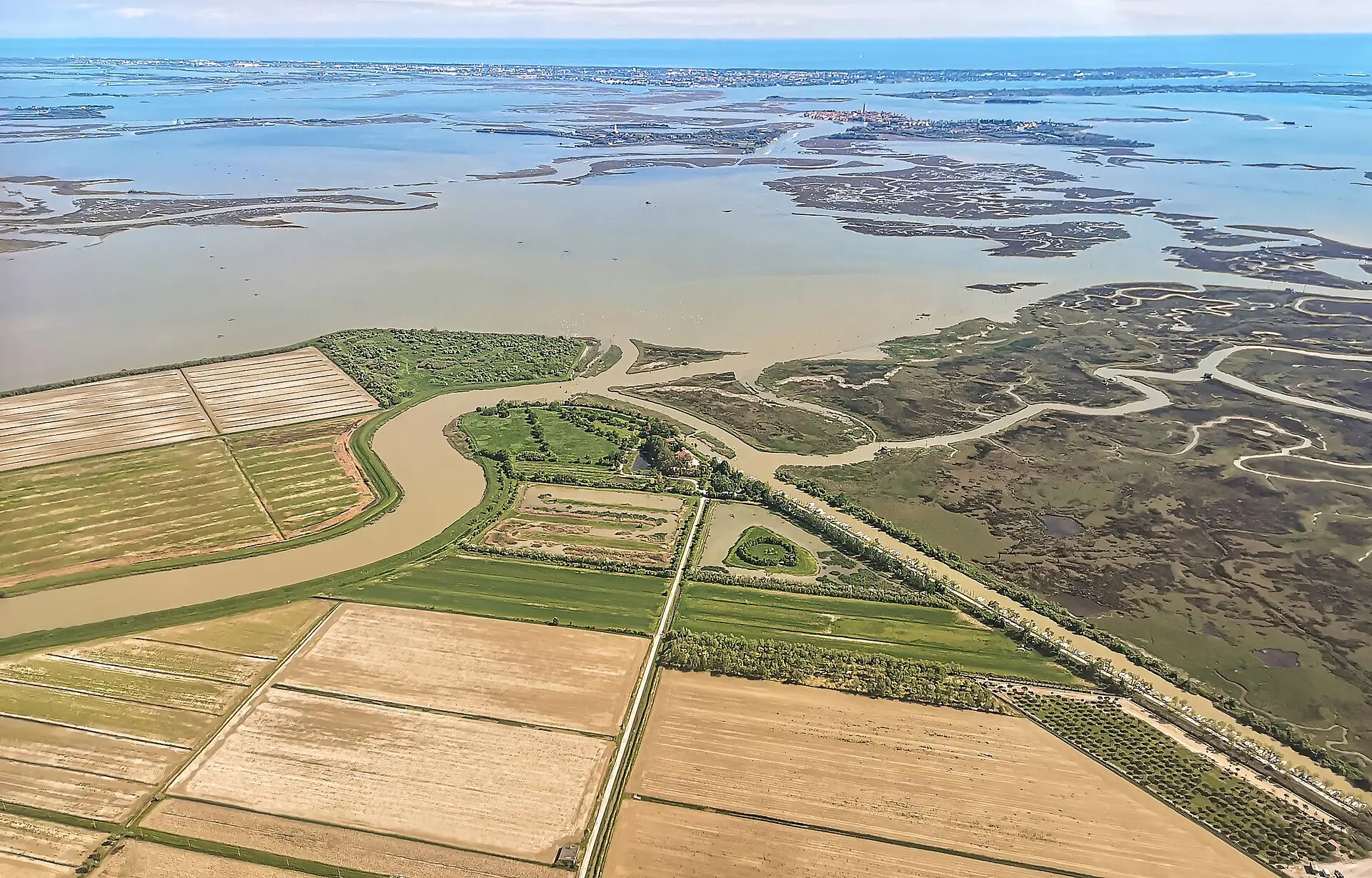
This article distinguishes observations from conditional projections and does not invent a date when Venice will disappear. For authoritative scientific background consult the IPCC Sixth Assessment Report, Working Group I, IPCC AR6 Synthesis Report, ISPRA, and the Venice tide forecast center. For local lagoon and coastal research consult Italy’s National Research Council. Featured image is a documentary photograph of the Venetian Lagoon; it is not an illustration of a projected future flood.