On November 4, 1966, Venice recorded an extraordinary high tide of 194 centimeters above its local tidal reference level. Sixty years later, the flood remains a defining moment in the city’s environmental and conservation history. Here is what happened, why the disaster mattered, and how to recognize its legacy without confusing historic records with today’s travel conditions.
The morning Venice could not forget
On November 4, 1966, Venice experienced a flood that changed how the city understood its vulnerability. Water reached 194 centimeters above the local tidal reference level, a record that has remained central to discussions of the lagoon’s risks. The photographs are startling: familiar squares become sheets of water, and buildings that seem eternal suddenly appear exposed. Sixty years later, the event deserves more than a dramatic caption. It offers a way to understand the relationship between weather, geography, historic architecture, and the people who maintain Venice.
For travelers arriving in October 2026, the anniversary provides a meaningful historical lens even though the disaster occurred in November. This article is not a general forecast of acqua alta or a guide to today’s flood alerts. It is a historical account of one extraordinary day, what the water revealed, and why the city’s response shaped later conservation and engineering debates. Distinguishing that purpose from practical high-tide advice helps preserve the integrity of both subjects.
What the number 194 centimeters means
Venice’s tidal heights are generally expressed relative to a local reference level used for the city’s tide measurements, rather than simply the sea level displayed on a global map. The 194-centimeter reading recorded on November 4, 1966 is therefore a specific historical measurement. It should not be casually translated into a claim that every street was under exactly 1.94 meters of water. Ground elevations differ across the city, and local conditions change from one place to another.
Understanding the measurement matters because flood photographs can be deceptive. One image might show water high against a doorway while another shows a shallower surface nearby. Both may be authentic. The city is uneven, and water levels interact with thresholds, steps, floors, and drainage. A careful account explains the reference level rather than exaggerating the depth in every neighborhood. This precision makes the catastrophe easier to understand, not less impressive.
A storm beyond the city
The 1966 disaster was not a picturesque high tide that arrived on an otherwise calm day. Severe meteorological conditions affected a much wider area of Italy, with destructive flooding also associated with Florence and other parts of the country. In Venice, atmospheric pressure, strong winds, and the behavior of the Adriatic combined with the lagoon’s geography to create exceptional conditions.
It is important not to present the lagoon as a closed basin responding to a single local rainfall shower. Venice is connected to the Adriatic through inlets, and sea conditions outside the lagoon influence water levels inside it. When persistent winds push water toward the northern Adriatic, the effects can become serious. The 1966 event reminds us that the fate of a narrow Venetian street may be linked to weather systems operating far beyond the city’s skyline.
Why the lagoon amplifies vulnerability
The lagoon is a shallow environment of channels, mudflats, islands, and engineered edges. It protects Venice in some ways while exposing the city to the movement of tides and storm-driven water. Over centuries, Venetians altered channels and waterways to support navigation and settlement. The result is a complicated relationship between natural processes and human decisions.
No single sentence can explain every cause of a historic flood. Changes in land levels, long-term sea-level trends, tidal dynamics, and unusual weather operate on different timescales. The extraordinary water level of 1966 was an event; the vulnerability of the city is a continuing condition. Keeping those categories separate helps visitors avoid two misleading extremes: claiming the disaster was inevitable, or treating it as a freak occurrence with no wider significance.
What the photographs actually show
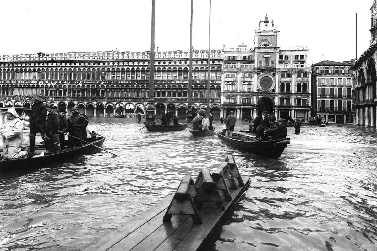
Historic images from November 1966 show Piazza San Marco and the surrounding ceremonial spaces transformed by water. The square’s familiar paving disappears, and the scale of the event becomes visible against recognizable architecture. These photographs are valuable historical documents, but they should be identified accurately. A picture of the 1966 flood must not be passed off as a current photograph of Venice.
The featured image for this article is an authentic archival photograph of Piazza San Marco during the flood, made available through Wikimedia Commons with a public-domain designation for Italy. It is not an AI reconstruction. A responsible publisher also checks the stated licensing conditions for the intended audience and use. The photograph captures a moment of crisis, not a representative scene of everyday autumn travel.
Piazza San Marco as a measuring place
St. Mark’s Square is often one of the first places travelers associate with high water because it is relatively low and frequently appears in flood coverage. Yet the square is more than a convenient photographic location. It is a historic civic and religious space surrounded by buildings that carry centuries of artistic and political history.
In 1966, flooding there dramatized a wider problem. Water could affect public movement, commercial premises, building materials, and the daily routines of people who worked nearby. Visitors looking at an archival photograph should ask what lies outside the frame: the shops trying to protect their interiors, the routes blocked elsewhere, and the crews attempting to keep services operating. The most famous image is only one fragment of a much larger urban experience.
The invisible damage to buildings
Flood damage is not measured solely by how high water climbs in a photograph. Historic masonry, plaster, timber, flooring, and interior finishes can be affected by prolonged contact with saline water. Salt may remain in porous materials after the visible water recedes, creating problems that require careful conservation rather than ordinary cleaning.
This is one reason Venice’s heritage faces a special maintenance challenge. A building can look normal from the outside while suffering deterioration inside its walls. Conservation specialists must understand moisture movement, salts, materials, and the history of previous repairs. The 1966 flood helped focus international attention on the vulnerability of a city whose artistic treasures cannot simply be moved away from the lagoon.
The people behind the landmark photographs
Historical coverage often emphasizes monuments, but residents experienced the flood as a disruption to homes, work, family routines, and essential services. Ground-floor rooms, shops, and storage spaces were especially exposed. Movement through the city became difficult, and the practical work of recovery continued after the water had receded.
We should resist inventing intimate eyewitness quotations to make the story more emotional. Real memories deserve accurate attribution, and not every dramatic anecdote circulating online has a verifiable source. Even without fabricated dialogue, the human implications are clear. A city of residents cannot be reduced to the condition of its stone façades. Its resilience depends on people who repair, clean, reopen, and adapt.
What happened beyond the historic center
The consequences of exceptional water were not confined to the area around St. Mark’s. Lagoon communities and islands experienced their own difficulties, shaped by location, exposure, and infrastructure. Accounts of the disaster describe serious impacts in places such as Pellestrina and Murano, reminding us that Venice is not only the historic island city seen on most postcards.
This wider geography is essential to the anniversary. A tourist map may place San Marco at the center, but the lagoon’s communities share environmental challenges while having different resources and physical conditions. A complete understanding of 1966 requires looking outward from the most photographed square toward the islands, shorelines, and working neighborhoods that form the broader Venetian environment.
The relationship with Florence’s flood
November 1966 also brought catastrophic flooding to Florence, where the rescue of damaged artworks became an internationally recognized story. The two disasters are often mentioned together, but they should not be confused. Florence’s river flood and Venice’s extreme lagoon water involved different local geographies and mechanisms.
The comparison is still illuminating. Both events showed that cultural heritage can be vulnerable to sudden environmental forces, and both encouraged international discussion about conservation. Venice’s problem was particularly complex because water is not an intruder from a distant river alone; it is also the medium through which the city historically operates. Protecting Venice means managing a relationship that cannot simply be eliminated.
Why 1966 became a turning point
The flood became a reference point in debates about how Venice should be protected. Its scale helped demonstrate that the city’s risks were not limited to occasional inconvenience. The event influenced public awareness and later planning, although the path from disaster to modern protective works was long and politically contested.
It would be inaccurate to say that one flood immediately produced a finished engineering solution. Major projects require research, legal decisions, funding, construction, and years of argument about environmental consequences. The 1966 event was a catalyst and a benchmark, not the sole cause of every policy that followed. This distinction matters whenever a historical disaster is used to explain modern infrastructure.
How preservation became an international concern
Venice’s buildings and artworks are globally significant, but they are also embedded in a living city. After 1966, international organizations, conservation groups, and supporters increasingly focused on the need for long-term protection. The disaster reinforced the idea that preserving Venice required sustained investment rather than occasional restoration campaigns.
That international attention is important, but it should not erase the role of Venetians themselves. Local institutions, craftspeople, engineers, residents, and maintenance workers carry out much of the work that keeps the city functioning. Outside assistance and local expertise are complementary. The anniversary offers an opportunity to acknowledge both without turning preservation into a story in which the city is merely a passive object of rescue.
The limits of romantic language
Descriptions of Venice as ‘sinking’ or ‘drowning’ may attract clicks, but they often compress several different phenomena into one dramatic phrase. Exceptional tides, long-term relative sea-level rise, land subsidence, and changing weather patterns are related questions, not interchangeable ones. An accurate historical article identifies which phenomenon it is discussing.
The flood of 1966 was a specific meteorological and tidal emergency. It should be examined through the records of that event, not used as evidence for every prediction about the city’s future. Readers deserve careful distinctions. Sensational language may create urgency, but precision creates understanding and helps travelers evaluate both historic images and contemporary news reports.
Why Venice is not a frozen museum
One of the most persistent misconceptions about Venice is that its historic appearance means its systems have remained unchanged. In reality, the city has continually adjusted its buildings, drainage, transport, and public services. The 1966 flood revealed vulnerabilities that demanded practical responses and difficult decisions.
Visitors can see evidence of adaptation throughout the city, from raised thresholds to temporary pedestrian walkways during high water. Not every intervention is a direct consequence of the 1966 disaster, and it would be misleading to claim otherwise. Together, however, these details show that Venice survives through maintenance and change. The city’s beauty is inseparable from the work required to sustain it.
The long road toward mobile barriers
The MOSE system of mobile barriers was developed as part of the effort to protect the lagoon from exceptionally high tides. Its movable gates are positioned at the lagoon inlets and can be raised under specified conditions to limit the entry of water from the Adriatic. The project took decades to develop and construct.
The system is frequently described as an answer to the kind of extreme event recorded in 1966, but its history includes complex engineering, environmental, financial, and political debates. It is not an invisible magic switch that removes every flood-related problem. A balanced account recognizes both the protective function of the barriers and the continuing need to manage the lagoon’s ecology, waterways, and urban infrastructure.
What MOSE does and does not do
Mobile barriers address a particular pathway through which exceptionally high sea levels enter the lagoon. Their operation is connected with forecasts and official procedures. They do not remove rain from every street, reverse centuries of architectural wear, or eliminate all questions about future sea-level conditions.
Travelers should also avoid assuming that the presence of MOSE means Venice can never experience water-related disruption. Local conditions, operating thresholds, and other factors remain relevant. For a current visit, official tide forecasts and public notices are more useful than a generalized claim that the city is either completely safe or permanently underwater. The history of 1966 makes the importance of that nuance clear.
The city and the science of tides
Venice’s tidal monitoring is a practical civic service. Measurements, forecasts, and warning systems help residents, businesses, transport operators, and visitors prepare for high water. Historical records such as the 194-centimeter level in 1966 form part of the long-term evidence used to understand extreme events.
A good guide distinguishes a forecast from an observed measurement and explains the reference level behind a number. If a visitor sees a predicted tide height, it is worth checking the official city information rather than interpreting the figure as the depth of water at every doorway. Venice is physically varied, and small differences in elevation can determine whether a particular route remains passable.
An anniversary that invites reflection
The sixtieth anniversary in 2026 is a chance to reconsider the event through both memory and evidence. Historic photographs, technical records, and conservation histories offer different ways of seeing the same day. None should be treated as complete on its own. A dramatic image shows the scale of flooding, while a tide record explains the measurement and a preservation report describes the longer aftermath.
For international visitors, the most rewarding approach is to connect these sources rather than seek a single sensational story. What happened? Why did the water rise so high? How did it affect ordinary life? What did the disaster change in public debate? These questions lead beyond the familiar photograph and toward a deeper understanding of the city.
A walking route through the memory of water
Begin in Piazza San Marco, where the archival images make it possible to compare historic and present-day views. Look at the paving, the building entrances, and the relationship between the square and the waterfront. Then continue toward the Piazzetta and the edge of the lagoon. The goal is not to recreate a disaster scene, but to understand how water and urban space meet.
Avoid claiming that a specific mark on a wall records the 1966 waterline unless an authoritative source identifies it. Venice contains many marks, repairs, and inscriptions with different histories. The best historical walk uses verified landmarks and encourages close observation. Give yourself time to look carefully rather than rushing between crowded photo stops.
Why the waterfront matters
From the edge of the Bacino di San Marco, the city’s exposure to open water becomes easier to imagine. Boats cross the basin, islands sit beyond the waterfront, and the lagoon’s connection to the Adriatic feels less abstract. This is a useful setting for explaining why an exceptional sea-level event can affect streets and squares inland.
The waterfront also demonstrates a paradox. The water that threatens buildings is part of the network that allows Venice to function. It carries public transport, supplies, and daily work. A serious account of the 1966 flood does not present the lagoon only as an enemy. It describes an environment that has sustained the city while also demanding continuous management.
A museum perspective on environmental history
Venice’s museums and cultural institutions provide valuable context for understanding the city’s relationship with water, even when they do not have a dedicated exhibition on the 1966 flood. Paintings, historic maps, maritime objects, and architectural collections show how the lagoon shaped Venetian identity over centuries.
Do not assume that a temporary exhibition is open simply because an older event listing appears online. For October 2026, verify museum schedules directly before making plans. The historical subject remains worth exploring independently of any one show. An informed visit can combine archival research with observations in the streets and waterfront spaces that shaped the disaster.
How to use archival images responsibly
Archival photography is powerful because it records conditions that are no longer present. It also requires care. The photographer, date, place, and rights status should be checked before publication. A scan may have been uploaded many years after the original exposure, and its digital metadata should not be confused with the date the photograph was taken.
For this article, the selected image is identified as Piazza San Marco during the flood of November 4, 1966, on Wikimedia Commons. It is a genuine historic image, not an artificial reconstruction. Its accompanying description and licensing information should remain accessible to readers. Responsible visual storytelling strengthens trust and prevents the common problem of unrelated flood photographs circulating with incorrect dates.
The difference between an anniversary and a prediction
An anniversary article looks backward. It can explain causes, consequences, and historical debates. It cannot reliably predict what weather Venice will experience on a future November day. Readers should be wary of stories that use the dramatic 1966 images to imply that an identical event is imminent.
Modern forecasts belong to meteorological and tidal services, which update information as conditions evolve. Historical comparison can help readers understand scale, but it is not a substitute for a current forecast. That separation is especially important for travelers planning a short stay. The best preparation combines curiosity about history with up-to-date practical information.
The work that happens after the water falls
The visible flood is only the beginning of a recovery story. Once water recedes, people must clean affected spaces, assess damage, protect materials, and restore ordinary routines. In a historic city, these tasks can require specialized knowledge because modern cleaning methods are not always appropriate for fragile surfaces.
This less photogenic work deserves attention. Restoration is not a single ceremonial moment when a monument reopens. It is a continuing process involving craftspeople, conservators, engineers, administrators, and residents. Understanding that labor changes the meaning of a flood photograph. What appears to be one extraordinary day may have consequences that extend for years.
The lessons for modern visitors
Visitors do not need to become tide engineers to appreciate Venice responsibly. They can begin by checking official forecasts when traveling during periods associated with high water, allowing flexibility in itineraries, and following public guidance about temporary walkways or transport changes. Respecting closures and avoiding unnecessary obstruction of local routes are practical forms of consideration.
It is also worth remembering that high water affects residents differently from short-term visitors. A traveler may regard an unusual tide as a memorable experience; someone living or working on the ground floor may face costly disruption. Historical knowledge encourages a more empathetic perspective. The 1966 anniversary is an opportunity to see Venice as a community, not just a collection of attractions.
A local guide’s perspective
The value of a knowledgeable guide is often the ability to connect what a visitor sees with the systems behind it. In Venice, a simple waterfront walk can open conversations about historic land levels, the movement of goods, preservation, and the daily adjustments required in a lagoon city. The 1966 flood provides a particularly vivid starting point.
Igor Scomparin has worked as a licensed guide since 1997, and Tour Leader Venice’s team approaches the city through both its history and practical realities. That experience does not justify inventing personal memories of 1966 or claiming first-hand knowledge of events that occurred before a guide’s career. It does help translate the city’s complex geography into observations travelers can recognize.
Further reading without repeating the story
If you want to understand the everyday systems that make Venice possible, read why Venice functions without cars. The article explains how the city’s unusual transportation network shapes practical life. For a closer look at the people who maintain that network, explore the workers who keep Venice running before sunrise.
A third complementary perspective comes from hidden details that reveal Venice’s real story. These links address logistics, labor, and urban observation rather than repeating a general high-tide guide. Together they help explain why the city’s resilience cannot be measured by monuments alone.
Why the story still matters sixty years later
The 1966 flood is remembered not simply because the water reached a record height, but because it exposed the vulnerability of a city whose cultural heritage and everyday life are inseparable. It helped shape conversations about protection, conservation, and the responsibilities shared by Venice and the wider world.
The most enduring lesson is neither despair nor complacency. Venice has survived through adaptation, but adaptation requires knowledge, maintenance, and choices about the future. Stand in Piazza San Marco with an authentic photograph from November 1966, and the square becomes more than a famous landmark. It becomes evidence of how a living city confronts extraordinary pressure.
Historical sources and photograph
For archival photographs, see the Wikimedia Commons collection of the 1966 Venice flood. For current tide warnings and water-level explanations, consult the City of Venice and its official tide information. The historical image associated with this article depicts Piazza San Marco on November 4, 1966; it is not a photograph of present-day conditions.
Explore related Venice stories
To put this subject into a wider Venetian context, explore the different boats that keep Venice moving, the engineering that supports the floating city and Venice’s water entrances and boat access. Each offers a complementary perspective on the city’s history, daily life, or cultural heritage.
More useful Venice reading
Continue with the science behind leaning Venetian palaces. These complementary guides help connect the topic to a broader Venice visit.
Frequently Asked Questions
How high did the water rise in Venice on November 4, 1966?
The recorded peak was 194 centimeters above Venice’s local tidal reference level. This does not mean every street was covered by exactly 194 centimeters of water, because ground elevations vary.
Why is the 1966 Venice flood historically important?
The disaster exposed the vulnerability of Venice’s historic buildings and residents, helped intensify international conservation attention, and became a benchmark in later discussions about protecting the lagoon.
Does the MOSE barrier system mean Venice can no longer flood?
MOSE is designed to reduce exceptional high tides entering the lagoon through its inlets. It does not remove every source of water-related disruption or eliminate the need for official forecasts and local precautions.