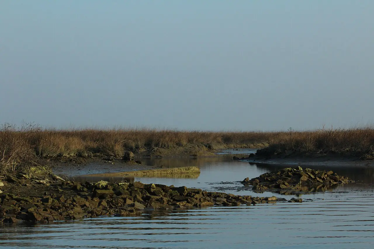
What does low tide reveal in the Venetian Lagoon? As water recedes, it exposes canal steps, water entrances, mudflats, salt-marsh edges, wooden navigation markers, and the vulnerable lower walls of Venice’s buildings. These details reveal how the city was constructed, how boats navigate, and why the lagoon is a living ecosystem rather than just a beautiful backdrop.
For travelers planning a visit to Venice, Italy, low tide is a chance to understand the city’s everyday relationship with water. It can also affect boat routes and hotel pickups. This guide explains what to look for, where to observe safely, and how to read the tide without confusing ordinary low water with a flood or a climate trend.
What low tide actually means in Venice
Low tide in Venice is the part of the tidal cycle when the lagoon’s water level falls, sometimes revealing surfaces normally concealed beneath the waterline. It is not a sign that Venice has suddenly run out of water, nor does it mean the entire lagoon becomes dry. A broad lagoon is a mosaic of channels, shallows, islands, salt marshes, and mudflats, each responding differently to the same changing level. A photograph of a narrow canal with an exposed bottom tells only a small part of that story.
The tidal range varies from day to day. The gravitational pull of the moon and sun provides the basic rhythm, while wind and atmospheric pressure can amplify or suppress the water level. The Adriatic is a semi-enclosed sea, and Venice sits at the northern end of a particularly sensitive basin. Persistent winds can push water toward or away from the lagoon, so a forecast tide is a prediction rather than an infallible appointment.
A visitor might hear the Italian expression acqua bassa, literally low water. It describes a familiar local condition, not an attraction with an admission ticket. A modest low tide may simply reveal a dark strip of brick or a little more of a wooden piling. A more pronounced one can leave small canals difficult to navigate and make a waterfront look unexpectedly skeletal. What is exposed depends on where you stand, the season, and the weather in the days before.
The lagoon is not one continuous sheet of water
From a high viewpoint, the Venetian Lagoon looks like a shimmering expanse surrounding the city. From a boat, its internal geography becomes more apparent. Navigable channels form watery roads, while broad shallow areas can lie surprisingly close to deeper routes. The lagoon’s tidal flats, known locally as velme, are normally submerged but emerge at low water. Salt marshes, or barene, sit at somewhat higher elevations and support plants adapted to saline conditions.
These distinctions matter because the lagoon is an ecosystem, not merely the picturesque setting for St. Mark’s Square. Its mud and vegetation help support fish, birds, and invertebrates. The edges between channels and shallows are biologically active. A passing traveler may see a grey-brown expanse and imagine it empty; in reality, the sediment is inhabited and connected to the food web of the Adriatic.
The view also helps explain why a skilled boat pilot reads the water rather than drawing a straight line between islands. A channel may be clearly marked by poles and still require careful navigation. A shortcut across a shallow bank can become impossible as the tide ebbs. The lagoon’s beauty is inseparable from this practical knowledge of depth, currents, and routes.
The exposed foundations of a floating city
One of the most revealing sights at low tide is not a dramatic mudflat but the bottom of a familiar building. Along canal edges, the water retreats from steps, stone blocks, brickwork, and the lower parts of foundations. These are the interfaces between Venice’s architecture and its aquatic environment. They remind us that Venice was built through generations of engineering, maintenance, adaptation, and close observation of water.
The popular shorthand that Venice floats on wooden piles is misleading. Its buildings do not bob on the surface. Builders historically drove timber piles into suitable sediments where required, created stable platforms, and laid masonry above. The details differ from site to site and across centuries. At low tide, you may see masonry and water entrances, but you should not assume that every visible piece of timber is a foundation pile or that the entire supporting structure is exposed.
What becomes visible is often a record of repair. Different bricks, patched joints, protective stone courses, and changes in surface color can reveal interventions made long after a palace’s original construction. The greenish band of algae, the dark stain of repeated wetting, and the lighter stone above form a rough visual diary of contact with water. None of those marks alone provides an exact historical sea-level measurement, but together they make the city’s physical vulnerability tangible.
Why steps disappear into the canals
Venice’s waterside staircases are among the details that visitors notice without always understanding. Many buildings once relied on boats for deliveries, passengers, and household necessities. A staircase descending into a canal was an entrance, not an ornamental flourish. At low tide, more steps may emerge and the practical geometry of the landing becomes easier to read.
The number of visible steps changes with the tide, but that does not mean each step was designed for a precise water level. Landing arrangements were shaped by boat types, local depth, construction dates, and repeated alterations. Some staircases are no longer used in the way they were centuries ago. Others remain important for access, though modern boats, safety rules, and the condition of the landing affect what is possible.
To understand these architectural details more deeply, read why Venice has so many steps leading into the water. The story is not just about masonry. It is about a society whose front doors often faced a canal and whose rhythms were coordinated with boats.
Water doors and the other side of Venetian palaces
The Grand Canal presents Venice’s ceremonial face, but smaller waterways expose the mechanics of everyday life. At low tide, a water door can sit unusually high above the surface. What looks like an awkward entrance today may have worked perfectly well with a different boat, a different landing arrangement, or a different operating water level.
Some entrances were associated with commercial deliveries; others served private residences. Warehouses, palaces, and workshops all needed access suited to their work. Reading these doors as evidence of how buildings functioned is more informative than treating every opening as a mysterious secret passage. Venetian architecture often combined impressive facades with remarkably practical arrangements.
For a companion perspective, see why Venetian buildings have doors that open directly onto the water. Together, water doors and exposed steps show that the lagoon was historically a transportation network integrated into the buildings themselves.
The wooden poles that mark safe passage
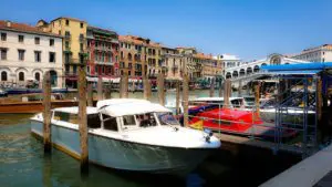
Long rows of wooden channel markers are among the lagoon’s most recognizable features. They are often called bricole, or briccole, and may appear in groups of poles. At low tide, their exposed length changes, making the contrast between marked channels and nearby shallow ground especially striking.
These poles are not a decorative attempt to make the lagoon look old-fashioned. They help boat operators identify channels and boundaries. They also remind travelers that open-looking water may conceal mudbanks close to the surface. Depending on the location, navigation may be governed by specific speed limits, channel rules, and restrictions designed to protect both people and the environment.
Visitors should never use a line of markers as permission to walk across an exposed flat. The mud may be deep, the tide may turn, and the area may be ecologically sensitive or subject to access restrictions. The safest way to appreciate the system is from a permitted shore path or an appropriately operated boat.
Mudflats are living habitats, not abandoned land
At low tide, the lagoon’s exposed sediments can appear austere: grey mud, shallow pools, ripples left by moving water, and occasional shells. Yet these surfaces host organisms that are crucial to the lagoon. Burrowing animals and small invertebrates help form the base of food chains used by fish and wading birds. Their activity also affects how sediment is mixed and processed.
Birdlife changes with season, weather, and location. Some species feed in shallow water or probe exposed mud for prey. Observing from a distance gives you a better chance of seeing natural behavior without disturbing feeding animals. Binoculars can be more useful than a telephoto-phone photograph taken after stepping too close.
The temptation to walk onto a newly exposed area is understandable, particularly when the surface looks firm. It may not be. Soft mud can trap shoes, and the return of water can isolate a person faster than expected. Protecting the lagoon and protecting yourself lead to the same advice: stay on authorized routes and never venture onto tidal flats without an appropriately qualified local operator and permission where required.
What the color of the canal walls can tell you
A low-tide walk can become a lesson in materials. The band of stone closest to the water is often discolored by algae, mineral deposits, and repeated wetting. Above it, brickwork may look drier and lighter. On timber, marine organisms and surface weathering create another set of textures. The precise pattern depends on shade, salinity, exposure, maintenance, and how often water reaches that point.
A dark band should not be presented as proof of a particular historic flood. Extraordinary acqua alta events and ordinary daily tides operate on different scales, and walls can retain marks for many reasons. For meaningful historical comparisons, researchers rely on calibrated measurements, documented reference levels, and carefully interpreted physical evidence rather than an attractive photograph alone.
Nevertheless, looking closely is worthwhile. A traveler who slows down beside an ordinary canal can begin to distinguish old stone, repaired mortar, tidal staining, and areas where waves or boat wash are wearing at the edges. The experience turns a casual walk into a study of how a working city survives contact with water.
The difference between low tide and acqua alta
Acqua alta means unusually high water, not low water. The two conditions belong to the same tidal environment but create very different visitor experiences. During a high-water episode, low-lying streets and squares may be affected; during a pronounced low tide, certain shallow canals can become hard for boats to use. Neither phenomenon should be confused with a citywide disaster every time the water level changes.
The official tide forecast is therefore useful even if you are not worried about flooding. A visitor planning a boat pickup, a gondola ride, or a photograph along a narrow canal may discover that low water matters as much as high water. Conditions can change quickly enough that a captain may choose another route or a different landing.
Venice’s tidal predictions use a local reference datum, and the reported centimeter value should not be interpreted as a simple water depth under every bridge. Canal beds differ, and so do clearances. A forecast of minus a certain number of centimeters does not tell you whether a particular boat will fit under a particular bridge or whether a particular landing is usable.
How low tide changes a boat tour
On the Grand Canal, a low tide may be little more than a visual change. In a narrow inner canal, the consequences can be operational. A captain may avoid a shallow section, approach a landing differently, or use a broader channel to reach the same destination. This is one reason a private boat itinerary in Venice should be flexible rather than promised as a fixed sequence of every picturesque canal.
A low bridge creates a different problem at high tide: there may be insufficient overhead clearance. Low tide generally increases clearance beneath bridges while decreasing depth above the canal bed. Those two constraints can pull in opposite directions. The workable route depends on the boat’s draft, height, local obstacles, and current conditions.
One useful local planning principle is to confirm the pickup point shortly before departure, especially for hotels on small canals. A hotel may advertise a water entrance without guaranteeing that every boat can use it at every tide. An experienced operator can arrange a nearby alternative pier when necessary. For American visitors accustomed to road transfers, this is an important distinction: the shortest route on a map is not always the workable route on the water.
Gondolas and the shallow-water problem
A gondola is designed for the waterways of Venice, but it is not immune to tidal conditions. Gondoliers know which canals offer sufficient water and how boat traffic, turning space, and current affect their route. When water is exceptionally low, a normal circuit may be shortened, changed, or temporarily impractical in particular locations.
That does not mean every low tide causes gondola rides to stop. Conditions are highly local. A broad canal can remain navigable while a nearby side canal is too shallow. Travelers should be wary of sweeping online claims that gondolas either always operate or always cease at a particular forecast number.
If a gondola ride is important to your itinerary, build in a little flexibility. A local guide can help explain what is happening, but the gondolier or licensed boat operator is responsible for safe navigation. A thoughtful alternative route can be more enjoyable than insisting on one narrow canal simply because it appeared in a social-media video.
What low tide reveals around the islands
The lagoon islands are not all built in the same way, and low tide can make their different shorelines clearer. Murano has canals, workshops, and a long history of glassmaking; Burano is surrounded by shallows and channels; Mazzorbo offers a quieter transition between settlement and lagoon landscape. On some approaches, exposed banks emphasize just how carefully navigation routes must be followed.
The temptation is to treat each island as a postcard floating in identical blue water. In fact, every island sits within a distinct arrangement of banks, currents, channels, and shore protection. A journey between them is an opportunity to observe the geography that made Venice possible and still shapes its daily logistics.
For island planning, see how to visit Murano, Mazzorbo, and Burano with a local guide. A private excursion can allow time to understand the landscape rather than treating the boat as a shuttle between shopping stops.
Salt marshes and the delicate edge of the lagoon
The barene, Venice’s salt marshes, are especially important in understanding the lagoon. They are not simply muddy islands waiting to be developed. Their vegetation is adapted to periodic inundation and salinity, and the marshes contribute to ecological processes and sediment dynamics. From a boat, they may look like low green or brown islands depending on the season.
Low tide helps distinguish the slightly raised marsh surface from the lower tidal flat. The difference can be subtle to an untrained eye but important to the organisms living there. Marsh erosion, changing sediment supply, and human alterations to channels are part of the wider conversation about the lagoon’s future.
Photographers should resist the idea that the best shot requires landing on a marsh. Disturbing vegetation or nesting and feeding areas can cause damage. The responsible approach is to photograph from a permitted boat route or designated observation area, using distance and light to show the extraordinary textures of the landscape.
A city shaped by sediment and centuries of decisions
Venice’s relationship with sediment is older than modern environmental policy. The republic invested heavily in managing waterways, protecting navigation, and addressing the effects of rivers that once carried sediment toward the lagoon. Over centuries, engineering interventions altered the system in ways that affected both commerce and ecology.
It is tempting to tell a simple story: the lagoon was natural until modern people interfered. The truth is more complicated. Venice has long been an inhabited and managed environment. Historic river diversions, channel works, embankments, and modern maritime infrastructure all form part of its changing geography.
Low tide makes this complexity visible because it exposes the physical boundary between the navigable and the non-navigable. A narrow channel beside a wide flat is not merely an accidental pattern. It can reflect currents, sediment behavior, and generations of decisions about where boats needed to travel. The lagoon is both a cultural landscape and a living estuary.
Is a very low tide caused by climate change?
A single unusually low tide cannot be attributed to climate change simply because it looks dramatic. Weather, astronomical tides, and regional sea conditions can produce short-term departures from average levels. Climate change and relative sea-level rise are serious long-term issues, but they require analysis across decades rather than interpretation of one morning’s photograph.
Venice also faces land subsidence and the legacy of historical human activity, making relative water levels especially important. Long-term sea-level rise generally increases the baseline from which high-water events occur, but it does not eliminate the daily rise and fall of the tide. Short-term low-water episodes can still happen within a long-term trend toward higher relative sea levels.
This distinction matters for accurate travel writing. A sensational headline about a dry canal may suggest that the lagoon is disappearing overnight; another about a flooded square may imply the city is permanently underwater. Neither image alone describes the full system. The most useful perspective comes from measurements, historical context, and attention to the difference between weather and climate.
The best places to notice low tide without taking risks
You do not need a boat or special access to see tidal changes. A walk along public waterfronts can reveal water marks, exposed steps, and the changing relationship between boats and landings. Look carefully around broad canal edges, where there is room to stop without obstructing residents. Public viewpoints on the Fondamente Nove side of Venice can offer a sense of the lagoon’s open-water character, while ordinary neighborhood canals show how low water affects daily life.
The Grand Canal offers the most recognizable architecture, but it is not necessarily the best place to appreciate exposed shallows. For those, the view from a legal, public location near the lagoon’s edges may be more informative. Conditions vary, and there is no single viewpoint that guarantees a dramatic low-tide scene every day.
Avoid stepping onto slippery canal stairs or down into an exposed canal bed. Algae-covered stone can be treacherous, and a surface that looks like a walkway may be unstable. Keep clear of working boat landings, do not block access for deliveries, and remember that private water doors are not invitations to explore.
Photography: texture, light, and the tide’s timetable
Low tide is particularly rewarding for photographers who enjoy details. The strongest images often contrast the grand skyline with humble evidence of daily work: a weathered pole, an exposed staircase, the underside of a landing, or a shallow pool reflecting an old brick wall. These subjects reveal a more intimate Venice than the standard sunset silhouette.
Early or late light can emphasize the textures of exposed sediment, but the tide will not necessarily be low at sunrise or sunset. Tidal timing shifts through the month, and wind can change the predicted level. Check the forecast first, then decide whether the light and location are worth the effort. A cloudy morning may reveal color and texture more clearly than harsh midday sun.
Use a longer focal length rather than walking into mud. Keep equipment away from wet, slippery edges, and do not set a tripod where it blocks a public passage. If you photograph people working on boats or at private landings, respect their space and ask before making close portraits. The lagoon is someone’s workplace, not only a backdrop.
How to read the official tide forecast
Venice has a municipal tide forecasting service, the Centro Previsioni e Segnalazioni Maree. Its forecasts are designed to help residents, operators, and visitors understand expected water levels. The official source is preferable to a generic travel blog when you need a forecast for a particular day. You can consult the city information at Venice’s municipal tide forecasting center.
When reading a forecast, check the date, local time, and reference system. A predicted minimum is not the same as the level for the entire afternoon. Wind and pressure can change conditions, so check again close to a boat transfer or planned activity. If you are comparing screenshots from different apps, make sure they use the same reference and update time.
For most visitors, the goal is not to become a tidal scientist. It is to make sensible choices: allow flexibility for a small-canal pickup, wear shoes with good grip, and understand why the city sometimes looks radically different from one visit to the next. The tide chart is a planning tool, not a guarantee of a particular photographic spectacle.
A November visit: what to expect
November brings shorter days and a different atmosphere to Venice. The lagoon can look austere under a grey sky, while the exposed surfaces of canals take on muted colors. Low tide can occur in any season, however, and November does not guarantee especially low water. Visitors should distinguish the season’s visual character from the astronomical and meteorological conditions that determine the tide.
Dress for damp conditions and wind rather than assuming the weather will be mild because the city is in Italy. Comfortable, grippy walking shoes are more useful than elaborate footwear if you plan to spend hours exploring canal edges. In early November, daylight hours are limited, so check sunset times and organize photography or island visits accordingly.
If you are planning a private lagoon trip, tell your operator what interests you: wildlife, historic navigation, architecture, photography, or local crafts. That information helps shape a realistic route. A good itinerary is responsive to the tide rather than built around an inflexible promise to reach every tiny canal at a fixed time.
What responsible visitors should never do
A dramatic low tide sometimes produces social-media images of people walking where boats normally float. That is not a safe or responsible model for sightseeing. Canal bottoms may contain deep mud, sharp debris, unstable surfaces, and contamination. Even if a particular area looks dry, the incoming tide and changing weather can create dangerous conditions.
Do not collect archaeological-looking objects, disturb sediment, remove shells or wildlife, or enter restricted lagoon habitats. Objects exposed by the tide may have heritage value, and disturbing them can damage the context that helps experts understand their history. If you notice something unusual, photograph it from a safe public location and inform the appropriate authorities rather than carrying it away.
Venice’s narrow passages and waterfronts are shared spaces. A photograph should never come at the cost of blocking a boat landing, climbing over a barrier, or inconveniencing residents. The most memorable encounters with the lagoon often come from quiet observation, patience, and an informed explanation rather than an attempt to get physically closer.
What a local guide can help you notice
The greatest advantage of local interpretation is not access to a secret patch of mud. It is the ability to connect details that otherwise seem unrelated: a canal staircase, a tide mark, a boat route, an old warehouse, and a distant line of navigation poles. Together, these elements tell the story of a city that developed through an unusually intimate relationship with water.
For American visitors, this can change the way an entire trip feels. A bridge becomes a viewpoint into engineering; a water door becomes evidence of an old delivery system; a lagoon crossing becomes a lesson in the difference between channels and shallows. The city is no longer simply a collection of monuments to check off a list.
Tour Leader Venice focuses on private, flexible experiences guided by people who know the city and lagoon. Igor Scomparin has worked as a licensed local guide since 1997. When planning a walk or boat experience, the team can discuss the practical implications of tides and choose routes suited to the conditions rather than promising that the water will behave on schedule.
The deeper lesson of an exposed lagoon
At high water, Venice can appear seamless: facades rise from reflective canals, and boats move through a city that seems to have been built for the camera. At low tide, the illusion changes. Mud, algae, foundations, and working landings come into view. The effect is not a loss of beauty but a different kind of honesty.
The exposed surfaces show that Venice is not separate from nature and not simply at its mercy. It is a place of continuing negotiation between human construction and an environment that moves twice daily and changes over centuries. That negotiation is visible in the smallest canal as well as in the broadest lagoon channel.
If you have only one day in Venice, you may never see a particularly dramatic low tide. That is fine. The lesson remains useful: pay attention to the edges of the water, ask why a staircase leads into a canal, and notice how carefully boats follow their routes. Venice’s most extraordinary stories are often hiding in plain sight, waiting for the tide—and a curious traveler—to reveal them.
Frequently Asked Questions About Low Tide in Venice
Does the Venetian Lagoon dry out at low tide?
No. Low tide can expose mudflats, steps, and shallow canal beds, but the lagoon’s deeper navigation channels retain water. How much is exposed depends on the predicted tide, wind, and local depth.
Can you take a gondola or private boat tour during low tide in Venice?
Often yes, but exceptionally low water may make some narrow canals or hotel landings inaccessible. A licensed operator may adjust the route or pickup point for safe navigation.
When is the best time to see low tide in Venice?
Check the official municipal tide forecast for the predicted daily minimum and its local time. Low tide is not tied to a fixed hour, and wind or atmospheric pressure can alter actual conditions.