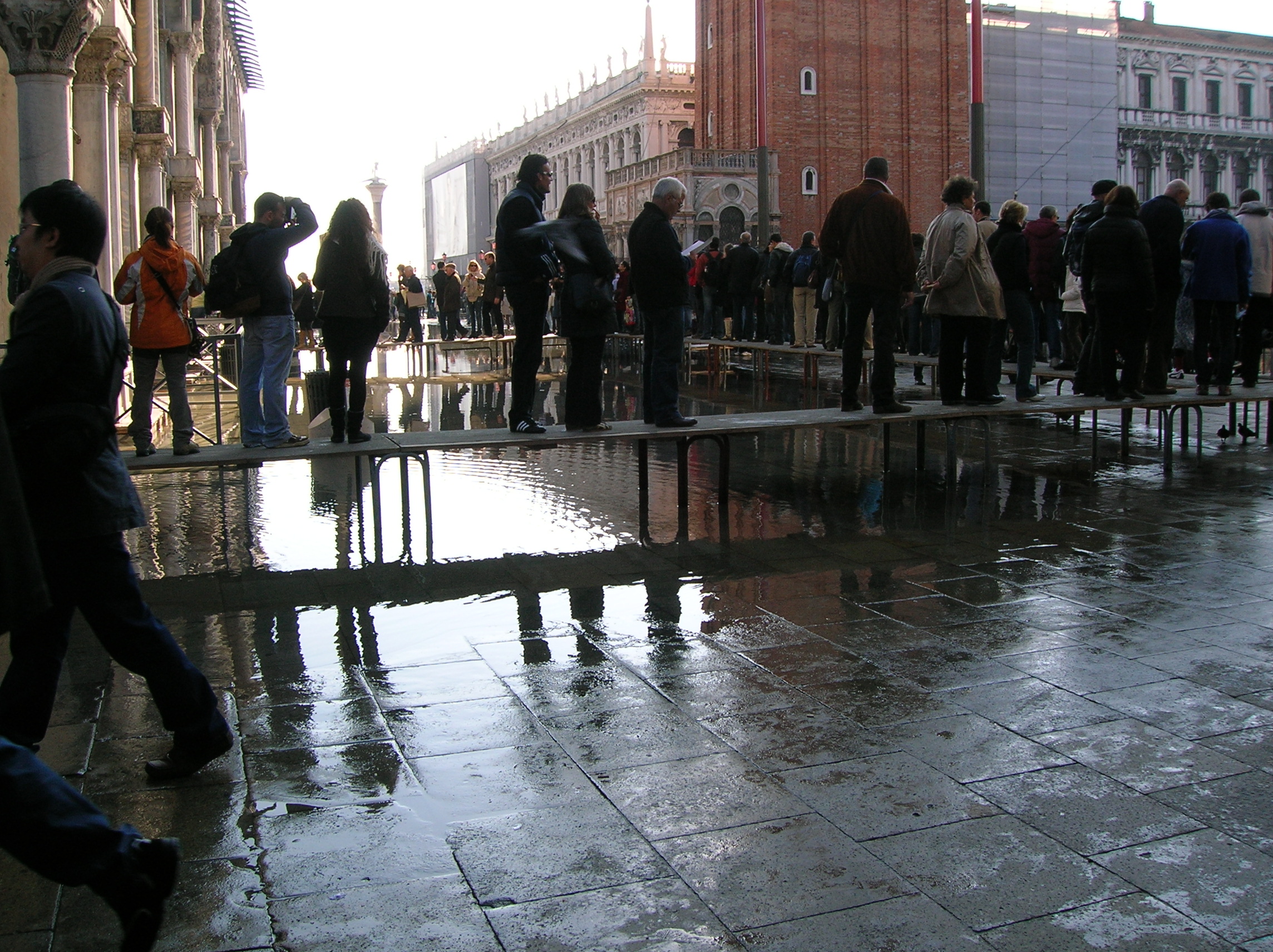
Acqua alta in Venice does not mean the entire city is flooded. If you are visiting St. Mark’s Square during a high tide, check the official tide forecast, use the hi!tide Venice app to understand water levels in specific places, and follow the city’s raised pedestrian walkways (passerelle) when they are installed and open. This guide explains what the numbers mean, how to walk safely, and why the platforms are not available everywhere.
The essential answer: how to handle high water
Acqua alta is a temporary rise in lagoon water that can cover low-lying streets and squares in Venice. It does not mean the entire city is underwater, nor does every forecast require changing your trip. The smartest first step is to check the official tide prediction, then look at the precise neighborhood you plan to visit.
St. Mark’s Square is one of the lowest and most visible places affected. When the city activates its seasonal pedestrian plan, raised platforms called passerelle can provide a dry walking route across selected flooded areas. They are not installed everywhere or at all tide levels. The free hi!tide Venice app helps you understand whether your actual destination may be wet.
Why this is not a generic flooding story
Venice’s water is part of its daily geography. The same canals that carry deliveries, commuters, and boats are connected to a lagoon influenced by the Adriatic Sea. Acqua alta happens when the water level rises enough to spill over some pedestrian surfaces. The effect is highly local: one square may have standing water while another remains dry.
Visitors often encounter dramatic photographs without the time, place, or measured tide attached. Those images can be misleading. A practical guide needs to explain what the measurements mean, why the temporary walkways appear, and how to check your route before leaving the hotel. That is the purpose of this article.
What the numbers in centimeters actually measure
Venice’s official tide heights are expressed relative to a conventional local reference level established in 1897, rather than the height of water above every street. If the forecast reads 100 centimeters, it does not mean there is one meter of water in Piazza San Marco. The ground in different neighborhoods sits at different elevations.
The city’s tide center has explained that a 100-centimeter tide may cover about five percent of pedestrian surfaces, while the lowest areas of St. Mark’s Square can have roughly 15 centimeters of water. These are illustrative conditions, not an exact prediction for every paving stone. The difference between a tide reading and actual water depth is the single most important concept for visitors.
Why St. Mark’s Square floods first
Piazza San Marco is relatively low compared with many other pedestrian areas. Water can therefore appear on its pavement at tide levels that leave large portions of Venice unaffected. A visitor walking from a dry neighborhood may be surprised to reach the square and find reflective pools or temporary barriers.
This is not evidence that the entire city has flooded. The piazza’s elevation makes it an early indicator of high water, but every route must be considered individually. Check the current local tide and follow staff instructions around the basilica and nearby arcades. Do not assume that a dry route through Castello or San Polo guarantees a dry crossing of the square.
What the raised platforms are called
The elevated pedestrian walkways are known in Italian as passerelle. They consist of temporary raised sections arranged to form designated routes when high water is expected. In photographs they can resemble narrow boardwalks above the flooded paving. They are a familiar part of the city’s seasonal response, not a permanent tourist attraction.
Their purpose is practical: to preserve access along selected corridors while water temporarily covers the ground. They are not intended as a place to stop for photographs or gather in large groups. Their width and capacity are limited, and their availability depends on the city’s operational plan and the actual water level.
Who puts the passerelle in place
The City of Venice publishes a seasonal pedestrian mobility plan. Its official information identifies VERITAS as the organization responsible for managing and placing the raised walkways. The deployment is based on forecasts issued by the municipal tide center, rather than an automatic decision made whenever the pavement looks damp.
This explains why visitors should not assume every walkway is already installed at sunrise or remains in place indefinitely. Teams must follow the relevant operational arrangements, and conditions may change. The official route plan is a planning aid; it is not a guarantee that every marked section is available at the exact moment you arrive.
The seasonal walkway plan
According to the city’s published pedestrian plan, the walkway service operates in the higher-risk season from September 15 through April 30. That does not mean platforms cover Venice continuously for seven months. They are placed when forecasts and municipal procedures call for them.
If you visit in summer, do not count on finding the same seasonal infrastructure ready to use. If you visit in October or November, check the forecast and current municipal notices rather than assuming platforms will appear for any puddle. The distinction between the season of readiness and actual deployment is easy to miss in generic travel advice.
What happens around 120 centimeters
The municipal plan describes designated raised pedestrian routes as usable up to a tide of approximately +120 centimeters. Above that level, some routes can become impracticable. This is a crucial limitation: a raised platform is not a universal flood barrier or a guarantee of dry access during every exceptional event.
The figure is an operational reference, not a personal safety threshold that you should try to test. Follow municipal instructions, local barriers, and staff directions. If the route is closed or unsafe, do not step onto it simply because an old map shows a walkway there. The safest itinerary is one that can change when conditions change.
How to walk on the platforms safely
When passerelle are open, move steadily and keep the route clear. Allow room for people approaching from the opposite direction and avoid stopping at the narrowest points. The walkways are meant for pedestrians to pass, not for sightseeing groups to assemble or for photographers to set up equipment.
Wet surfaces, crowding, and awkward luggage can make a short crossing less comfortable than it appears in pictures. Keep children close and take particular care if you have balance or mobility difficulties. If an official has restricted access, respect that instruction. No photograph of a flooded piazza is worth creating a hazard for yourself or others.
The practical mistake with suitcases
A traveler pulling a heavy suitcase may look at a raised walkway and assume it solves the whole route from a boat stop to a hotel. In reality, the platform covers only a selected section. Before and after it, there may still be wet pavement, steps, bridges, or a congested passage.
This is one reason hotel arrival planning deserves more attention during a high-water forecast. Ask your accommodation about the nearest suitable landing and the route to its entrance. A private water taxi is not a magic solution if the canal approach or water door cannot be used under current conditions. Plan the final hundred yards, not just the boat ride.
How hi!tide Venice helps
The hi!tide Venice app was developed in collaboration with Venice’s municipal tide forecasting service and uses official tide data. Its purpose is to make water levels understandable at specific places, not merely to show one citywide number. It includes locations such as San Marco, Rialto, Ferrovia, and Piazzale Roma.
That place-based approach is exactly what visitors need. Rather than asking whether Venice is flooded in the abstract, you can investigate whether the area you want to reach is expected to have water. The app is a planning aid, not a replacement for municipal warnings or barriers at the scene.
Where to download the correct app
The iPhone version is listed as hi!tide Venice on the Apple App Store, while the Android version appears as High Tide Venice – Hi!Tide on Google Play. Use the official store listings and check the developer information rather than installing a similarly named application from an unfamiliar source.
The Apple listing describes the app as free and provides information about actual tide levels and predictions for the next two days. The Android listing also describes configurable notifications. Features can vary by platform or version, so check what your own device offers. The central benefit is the official tide information, not a promise of identical controls on every phone.
Reading the current tide in the app
Begin with the current measured level, then compare it with the forecast peak and the time of that peak. A number without a time can mislead: the water may be rising, near its maximum, or already falling. The timing matters when deciding whether to leave the hotel immediately or wait for conditions to improve.
Next, select the relevant place rather than relying only on a citywide summary. A traveler heading to San Marco needs different information from someone walking near the station. Recheck before departing, particularly if the weather changes. The most useful app habit is to combine level, location, and time.
How to use the location information
The app provides place-specific indications for important areas and ACTV stops. This is valuable because a flooded square does not necessarily mean your waterbus stop is inaccessible, and a dry stop does not guarantee that every nearby alley is dry. You need to understand the entire short walking route.
For example, if your hotel is near Rialto and you have a morning visit at San Marco, check both neighborhoods and the route between them. If one section is wet, ask whether the official walkway plan or a different approach offers a sensible alternative. Do not assume the app is a turn-by-turn evacuation system; it is a source of tide and location information.
What a two-day forecast can and cannot tell you
Hi!tide’s official descriptions mention detailed predictions for roughly the following two days. That is useful for arranging a museum visit, choosing a morning departure, or deciding when to move luggage. It does not guarantee exact conditions a week later or replace the latest updates from the tide center.
Meteorological influences can alter the situation, so recheck closer to the event. A hotel or guide who gives you an unqualified prediction several days ahead is oversimplifying a changing phenomenon. The best approach is to make a flexible plan and confirm it against the latest official information.
Official municipal tide forecasts
The City of Venice’s Centro Previsioni e Segnalazioni Maree is the primary public source for observed and forecast water levels. Its website includes tide bulletins, real-time data, pedestrian walkway information, and other practical notices. The city also offers Telegram information channels and alerts.
Save the official page before traveling. If an app appears inconsistent with a municipal notice, prioritize the current instructions issued by the responsible authority. An official forecast is more useful than a viral video without a date. When conditions are exceptional, the city’s guidance and the decisions of emergency services take precedence over any travel itinerary.
What the sirens mean
Venice has an acoustic warning system for significant high-water events. Visitors may hear sirens or signals and wonder whether they indicate a general emergency. These alerts are part of the city’s system for communicating tide risk and should prompt you to check official information.
Do not guess the predicted water level by counting sounds unless you have consulted the current official explanation of the signals. Instead, use the municipal tide center, posted notices, and staff instructions. If you are inside a hotel or museum, ask personnel about the practical implications for your route. An alert is a reason to seek accurate information, not to panic.
How long acqua alta usually lasts
Acqua alta is often a temporary event associated with the tidal cycle. The City of Venice explains that a tide reaching a maximum of around 120 centimeters commonly has a relatively short peak, with the most significant effects often lasting a limited period. That makes timing an important planning tool.
This does not mean every event ends on the same schedule. Weather and exceptional conditions can change the duration and severity. If you have a flexible sightseeing day, a sheltered museum or leisurely breakfast may be preferable to rushing across wet streets at the predicted maximum. Check the forecast curve, not just the headline number.
Why the city is not uniformly underwater
Venice has a varied pedestrian topography. Bridges, embankments, squares, and alleys sit at different heights. Water reaches the lowest surfaces first, which is why photographs taken in Piazza San Marco can look dramatic even when much of the historic center remains walkable.
For travelers, the implication is reassuring but practical. You may not need to cancel the entire day, but you should adapt the route. A destination near a low waterfront may be more difficult than a church several streets inland. Ask precise questions about access instead of treating the whole city as one undifferentiated flooded area.
What happens to the vaporetto
ACTV waterbuses generally continue operating during many high-water events, but routes can change when canal and bridge conditions make navigation difficult. The city notes that certain service changes can occur above approximately 95 centimeters, while exceptional tides can create more substantial disruption.
The reason is not simply that there is too much water to float a boat. Higher water reduces clearance beneath some bridges and can complicate access to particular landings. Check the ACTV service notices and ask staff at the stop. A waterbus ticket does not guarantee that every scheduled stop will be served in unchanged conditions.
Why water taxis also face restrictions
A private water taxi can offer comfort and a direct journey to an appropriate landing, but it cannot ignore bridge clearance, canal dimensions, tides, or navigation rules. Some hotel water doors are inaccessible at high water because the boat cannot pass beneath a bridge on the approach.
This is an operational detail travelers rarely see in glossy brochures. A hotel advertised as having a private canal entrance may still require a short walk from another pier on certain days. If you are traveling with luggage or limited mobility, ask the provider about contingency arrangements before confirming a transfer.
What MOSE changes
MOSE is Venice’s system of mobile barriers designed to protect the lagoon from certain exceptional high tides. When activated under the relevant operating conditions, the barriers separate the lagoon from the Adriatic Sea at the inlets. This has changed how some high-water events affect the historic center.
It has not made every puddle or local flooding problem disappear. Lower-lying parts of San Marco can still experience water under certain conditions, and the operation of the barriers depends on official decisions and forecasts. Visitors should not assume that MOSE guarantees dry pavement at every moment. The correct response remains to check current conditions.
Why San Marco remains a special case
St. Mark’s Square has a distinctive combination of low elevation, extraordinary visitor traffic, and sensitive historic buildings. Its water problems cannot be understood solely through the dramatic events that once made international headlines. Even comparatively modest tides can affect particular sections.
For this reason, the area has been the focus of protective and management measures, and visitor access can be organized differently according to conditions. Follow local signs rather than assuming the same entrance to a landmark will be available every day. If you have a timed ticket, verify the venue’s current access advice.
Museum tickets and timed entrances
If you have a timed visit to St. Mark’s Basilica or the Doge’s Palace, do not assume that a high-water forecast automatically cancels your reservation. Check the venue’s official notices and any instructions sent with the ticket. The entrance route may matter more than the existence of water elsewhere in the square.
Allow additional time for walking and queues on raised platforms. If you are uncertain, contact the venue or your guide before leaving. A booking confirmation does not grant permission to bypass municipal barriers. Flexibility is especially important for travelers arriving from the station or another island on the same morning.
What shoes actually help
Waterproof footwear with a secure grip is useful during the cooler months, especially if rain or shallow water is forecast. Ordinary sneakers can become uncomfortable when soaked, while flimsy disposable overshoes may provide less traction than expected. Choose footwear suited to your mobility and the conditions.
Avoid treating boots as a license to walk through deep or fast-moving water. You may encounter uneven paving, hidden steps, or slippery surfaces. If an official walkway is open, use it as directed. When water is too deep or a route is closed, find another route or wait rather than pushing through simply because you packed rubber boots.
Advice for families with children
Children may be fascinated by a flooded square, but the novelty can conceal hazards. Keep them close on narrow passerelle, explain that the water is not a playground, and avoid stopping where people need to pass. Carry spare socks or a change of clothing if you expect a wet day.
Choose shorter outdoor segments and include sheltered stops. If a stroller is difficult to manage on a narrow platform or over bridges, ask about alternatives. A family itinerary should respond to actual conditions, not to the assumption that every landmark must be reached at the original time.
Advice for travelers with reduced mobility
High water can make an already complex pedestrian environment more difficult. Raised platforms may not be suitable for every wheelchair or mobility device, and their presence does not guarantee a fully accessible route. The surrounding streets and bridges must also be considered.
Contact your accommodation and the relevant transport operator before setting out. Ask about the exact landing and entrance, not just whether a district is accessible in general. If a planned route becomes unsafe, changing the itinerary is a sensible decision. No visitor should be pressured to attempt a difficult crossing to preserve a sightseeing schedule.
A practical morning example
Imagine you are staying near the Rialto Bridge and have a late-morning visit in St. Mark’s Square. Before breakfast, check the municipal forecast for the expected peak and consult hi!tide for both Rialto and San Marco. Then check whether the city has announced raised walkway deployment.
If the peak coincides with your appointment, contact the venue or guide and decide whether to allow more time, take an authorized alternative route, or adjust the visit. Do not assume a map application will know which temporary platforms are currently in place. The difference between a stressful morning and a manageable one is often this short check before leaving.
A second example: arrival with luggage
Suppose your train reaches Santa Lucia while a high tide is predicted. Check the Ferrovia area, your destination stop, and the final walk to your hotel. If you have arranged a water taxi, confirm the landing with the operator and accommodation rather than insisting on a canal entrance that may be unavailable.
If you are using ACTV, consult service alerts and keep a reasonable buffer for any changed stop. Do not drag suitcases into flooded alleys without knowing where the route leads. A few minutes of coordination may prevent a much longer detour across wet paving and bridges.
The local detail that changes everything
A tide figure is not a travel itinerary. The most important practical question is whether the specific stretch between your arrival point and your destination remains passable. This is particularly relevant around San Marco, where a few yards of low paving can separate a dry approach from standing water.
Licensed Venice guide Igor Scomparin, guiding since 1997, and the Tour Leader Venice team work with the city’s distinctive transport and pedestrian constraints. A responsible local approach does not promise that every hotel water door or museum entrance will be reachable. It checks the actual route, keeps a workable alternative, and communicates changes clearly.
What to avoid during a high tide
Avoid crowding onto a narrow walkway for a selfie, ignoring temporary barriers, stepping into water of uncertain depth, or blocking residents who are trying to reach work. Do not assume that a viral photograph represents today’s conditions. And do not treat emergency crews or maintenance workers as part of a tourist performance.
Venice is a working city. Its raised walkways are infrastructure intended to keep people moving safely. Respecting that purpose makes the experience better for everyone. If the situation looks unsafe, step aside, consult official information, and change your plans rather than following a crowd into an uncertain route.
Three complementary Venice articles
For a broader historical explanation of flooding and its long-term consequences, read the hidden details that explain how Venice really works. To understand why road vehicles cannot simply reach a flooded hotel, explore why Venice has no cars.
For a picture of the people who keep the city functioning under unusual conditions, see how Venice works before sunrise. These three existing Tour Leader Venice articles provide context without duplicating this practical guide to hi!tide, temporary walkways, and San Marco access.
The most useful five-minute routine
Before going out, check the official Centro Maree forecast. Open hi!tide and examine your destination, not just the overall water level. Look for municipal walkway notices, then verify ACTV or water-taxi arrangements if your route includes a boat. Finally, ask your hotel about any access changes.
This routine will not eliminate every inconvenience, but it replaces guesswork with actionable information. Venice can remain beautiful and enjoyable during a modest high tide. The key is to understand that conditions vary by street, time, and water level. Plan around those facts, and let the city reveal itself without unnecessary stress.
Official tide and app resources
Check the City of Venice tide forecasting center and the official raised-walkway plan. Download hi!tide Venice for iPhone or Hi!Tide for Android. The city explains how high water affects pedestrian routes. Check current notices before travel; forecasts and operations change.
Featured photograph: authentic archival image of visitors on raised walkways near St. Mark’s Basilica, by Giovanni.mello, Wikimedia Commons, GFDL. This image is from 2008 and does not depict current conditions. Photo and licensing details.
Related Venice guides
To understand the city’s infrastructure and plan with more confidence, read about how Venice was built on the lagoon; why some Venetian palaces lean; water entrances on Venetian buildings.
Frequently Asked Questions
How do you walk through St. Mark’s Square during acqua alta?
Follow the official raised walkways (passerelle) when they are installed and open, obey municipal barriers, and check the tide forecast. The city’s walkway network is designed for selected routes up to approximately +120 cm; some routes can become unusable above that.
What does the hi!tide Venice app tell you?
It shows current and forecast tide levels using official municipal data and gives place-specific indications for areas including San Marco, Rialto, Ferrovia, and ACTV waterbus stops. Check the official municipal notices for restrictions.
Does a forecast of 100 cm mean one meter of water in Venice’s streets?
No. The number is measured against a conventional local tide datum, not street level. Different parts of Venice have different elevations; at a 100 cm tide much of the city can remain dry while low areas of St. Mark’s Square may have shallow standing water.