Which islands disappeared from the Venetian Lagoon? The medieval districts of Ammiana and Costanziaco, north of Torcello, lost their inhabited communities and much of their former land over centuries. Archaeological research identifies surviving fragments including Sant’Ariano, La Cura, and sites associated with San Lorenzo di Ammiana. They did not vanish in a single documented catastrophe: shifting channels, environmental stress, abandonment, and erosion changed their geography over time.
Behind the phrase Venice’s lost islands lies a remarkable story of monasteries, farms, medieval settlements, and archaeologists piecing together a vanished landscape from old maps and traces beneath the water. This guide distinguishes documented discoveries from legends and explains what a curious visitor can responsibly explore today.
A lagoon with missing names
On a modern map, the northern Venetian Lagoon appears as an intricate arrangement of islands, salt marshes, tidal channels, and shallow water. Torcello and Burano have familiar names. Yet medieval documents and archaeological studies describe other communities whose names are no longer attached to inhabited islands. Ammiana and Costanziaco were not imaginary cities swallowed in a single dramatic night. They were settlements in a changing landscape, gradually abandoned and physically altered. Understanding what disappeared requires separating the loss of people, buildings, dry land, and historical memory. Those losses did not necessarily occur together.
Historical geography requires particular care with place names. A medieval district may refer to a group of islands rather than one landmass, and the same name can shift in meaning across documents. Readers should therefore resist matching a medieval label to a single modern point without examining the underlying research. The distinction is not pedantic: it changes what we can responsibly say has survived.
The question hidden in the title
What does it mean for an island to disappear? A village can be deserted while its ground remains visible. A monastery can be demolished while a channel preserves its name. A once-continuous island can fragment into smaller patches of land. Finally, some surfaces can become submerged or buried beneath marsh sediments. In the Venetian Lagoon all these processes have occurred. The phrase lost island is useful for attracting attention, but the historical reality is more complicated. Researchers reconstruct different moments from documents, maps, underwater finds, and sediment layers, rather than assuming a single catastrophe.
The northern lagoon is also a place where scale deceives. From a boat, a low strip of land may look insignificant, while archival records reveal centuries of activity in the surrounding waterways. Conversely, a picturesque island visible today may have changed greatly since medieval times. Appearance alone cannot establish historical continuity. Archaeology supplies the missing dimensions of time and human occupation.
Venice before the Venice we know
The medieval lagoon did not develop only around Rialto. The northern basin supported networks of settlements connected with the mainland, waterways, agriculture, trade, and religious institutions. Some were important before the urban center of Venice achieved its later dominance. This is why vanished islands matter to the history of the whole region. They show that the city was not born fully formed in its present location. Communities developed, prospered, shifted, and sometimes ceased to exist as environmental and economic conditions changed. The history of Venice is also a history of places that did not become Venice.
The story is best read through evidence rather than nostalgia. A vanished church does not necessarily prove a vanished island, and a submerged wall does not tell us when the last resident departed. These questions require different sources and sometimes yield different answers. A responsible account can acknowledge uncertainty while still revealing the extraordinary complexity of the lagoon’s past.
Ammiana: more than a legend
Ammiana occupied an area of the northern lagoon near the channels of San Felice, west of the territory associated with Costanziaco. The name appears in early medieval records, including the ninth-century Pactum Lotharii. Archaeological scholarship describes a district of islands and religious communities, rather than one compact urban center. Recent research emphasizes gradual ecological and settlement change instead of the popular image of a Venetian Atlantis suddenly sinking. The distinction is essential: a dramatic legend may be memorable, but surviving records point toward a long and uneven transformation.
Historical geography requires particular care with place names. A medieval district may refer to a group of islands rather than one landmass, and the same name can shift in meaning across documents. Readers should therefore resist matching a medieval label to a single modern point without examining the underlying research. The distinction is not pedantic: it changes what we can responsibly say has survived.
The evidence of the Pactum Lotharii
The Pactum Lotharii of 840 is significant because it identifies communities in the lagoon long before many familiar Venetian monuments existed. References to Ammiana alongside other lagoon settlements indicate its recognized place in the political and economic geography of the time. A document like this does not supply a modern street map, population count, or detailed outline of the islands. It establishes that a named community mattered enough to be recorded. Historians combine that written evidence with later charters and archaeology to understand what the name represented across centuries.
The northern lagoon is also a place where scale deceives. From a boat, a low strip of land may look insignificant, while archival records reveal centuries of activity in the surrounding waterways. Conversely, a picturesque island visible today may have changed greatly since medieval times. Appearance alone cannot establish historical continuity. Archaeology supplies the missing dimensions of time and human occupation.
San Lorenzo di Ammiana
The archaeological site of San Lorenzo is especially valuable because its layers preserve traces of changing occupation. A study led by Sauro Gelichi and colleagues examines San Lorenzo through excavation and historical sources, showing the importance of a monastic community in the late medieval landscape. The documentary record identifies a church and later a Benedictine foundation. The convent’s abandonment in 1438 marks a clear institutional turning point, but it should not be mistaken for the exact date when the entire island physically vanished. Religious abandonment and geomorphological disappearance follow different timelines.
The story is best read through evidence rather than nostalgia. A vanished church does not necessarily prove a vanished island, and a submerged wall does not tell us when the last resident departed. These questions require different sources and sometimes yield different answers. A responsible account can acknowledge uncertainty while still revealing the extraordinary complexity of the lagoon’s past.
What happened to the monasteries?
Medieval religious houses were not merely isolated places of prayer. They could own land, manage resources, maintain buildings, and participate in regional economic networks. Their abandonment therefore tells us about changing conditions across a wider territory. The State Archive of Venice’s exhibition on a sixteenth-century lagoon map documents several monasteries that had been transferred or were already in ruins by the time of Cristoforo Sabbadino’s survey. Those moves occurred over decades, not all at once. A church’s ruins on an old map may represent a settlement’s final visible phase, long after most residents had left.
Historical geography requires particular care with place names. A medieval district may refer to a group of islands rather than one landmass, and the same name can shift in meaning across documents. Readers should therefore resist matching a medieval label to a single modern point without examining the underlying research. The distinction is not pedantic: it changes what we can responsibly say has survived.
The surviving pieces of Ammiana
Names such as Santa Cristina, La Salina, and Motta di San Lorenzo are associated with remnants of the wider Ammiana landscape. Their exact relationship to medieval shorelines must be interpreted through historical and archaeological research. A visitor should not imagine that each surviving patch corresponds neatly to one complete medieval island. Channels migrate, banks erode, and marsh deposits reshape edges. What survives can be a fragment, a later landform, or a site with several phases of use. The northern lagoon is a palimpsest rather than a preserved scale model of its medieval geography.
The northern lagoon is also a place where scale deceives. From a boat, a low strip of land may look insignificant, while archival records reveal centuries of activity in the surrounding waterways. Conversely, a picturesque island visible today may have changed greatly since medieval times. Appearance alone cannot establish historical continuity. Archaeology supplies the missing dimensions of time and human occupation.
Costanziaco: the other lost archipelago
Costanziaco, also written Constanciacus or Costanziaca, lay in the northern lagoon near Ammiana and Torcello. Archaeological research identifies it as a group of islands with settlements and religious buildings. The name has largely vanished from modern visitor maps, although parts of the old territory survive above water. Researchers studying the Vicus Costanziaci project describe Sant’Ariano and La Cura as two remaining emerged strips. That precise observation is more informative than claiming an entire city lies intact beneath the lagoon. The evidence points to a landscape that changed shape while its institutions disappeared.
The story is best read through evidence rather than nostalgia. A vanished church does not necessarily prove a vanished island, and a submerged wall does not tell us when the last resident departed. These questions require different sources and sometimes yield different answers. A responsible account can acknowledge uncertainty while still revealing the extraordinary complexity of the lagoon’s past.
Sant’Ariano and La Cura
Sant’Ariano and La Cura are important because they offer geographical anchors for reconstructing Costanziaco. They are not normal sightseeing islands with public ferry services, museums, and open visitor paths. The remains are part of a fragile archaeological and ecological landscape. Research has combined surface finds, underwater survey, archive documents, and remote sensing to reconstruct the ancient settlement. The presence of surviving land should not encourage casual landings or artifact collecting. In a protected lagoon environment, scientific access and visitor access are very different matters.
Historical geography requires particular care with place names. A medieval district may refer to a group of islands rather than one landmass, and the same name can shift in meaning across documents. Readers should therefore resist matching a medieval label to a single modern point without examining the underlying research. The distinction is not pedantic: it changes what we can responsibly say has survived.
The map drawn in 1553
One of the most revealing sources is a drawing made in 1553 by Cristoforo Sabbadino, preserved and discussed by the State Archive of Venice. It depicts the lagoon between the old mouth of the Sile and the San Felice channel. The archive explains that Ammiana and Costanziaco were already largely abandoned and altered by Sabbadino’s time. Several monastic sites are shown in ruins. The drawing is evidence of historical change, not a photograph of an untouched medieval landscape. Comparing it with today’s geography reveals how much the waterways and landforms have shifted.
The northern lagoon is also a place where scale deceives. From a boat, a low strip of land may look insignificant, while archival records reveal centuries of activity in the surrounding waterways. Conversely, a picturesque island visible today may have changed greatly since medieval times. Appearance alone cannot establish historical continuity. Archaeology supplies the missing dimensions of time and human occupation.
Why the old map matters
Sabbadino’s map is especially powerful because it captures a landscape in transition. By the mid-sixteenth century, the decline of former religious settlements was already part of the region’s history. The map records traces that would become harder to recognize in later centuries. It also reminds us that the lagoon was actively studied and managed by Venetian authorities. Water was never simply a picturesque setting. Its movement affected navigation, agriculture, settlement, and the survival of buildings. The same physical processes that enabled lagoon communities could eventually make their locations difficult to inhabit.
The story is best read through evidence rather than nostalgia. A vanished church does not necessarily prove a vanished island, and a submerged wall does not tell us when the last resident departed. These questions require different sources and sometimes yield different answers. A responsible account can acknowledge uncertainty while still revealing the extraordinary complexity of the lagoon’s past.
Not a single wave of destruction
Popular accounts sometimes describe Ammiana and Costanziaco as places swept away by a sudden flood. The archaeological and historical literature offers a more complex explanation involving gradual abandonment, environmental changes, and long-term alteration of the land. Individual storms may have damaged particular sites, but it is not sound to assign the disappearance of an entire archipelago to one undocumented disaster. The distinction matters because dramatic storytelling can erase the actual choices people made. Families and religious communities could relocate in response to worsening conditions before their buildings or fields were physically lost.
Historical geography requires particular care with place names. A medieval district may refer to a group of islands rather than one landmass, and the same name can shift in meaning across documents. Readers should therefore resist matching a medieval label to a single modern point without examining the underlying research. The distinction is not pedantic: it changes what we can responsibly say has survived.
The role of river sediments
Rivers carried sediments toward the lagoon, affecting channels and shallow-water environments. Changes in the Sile and Piave systems contributed to the evolution of the northern basin, while later hydraulic interventions altered water flows. Sedimentation can make a channel shallower, change drainage, and influence the balance between open water, marsh, and dry land. These processes are not simple: an area can gain sediment in one location while another bank erodes. Research on the vanished settlements connects hydrological change with the difficulty of maintaining habitable land and navigable connections.
The northern lagoon is also a place where scale deceives. From a boat, a low strip of land may look insignificant, while archival records reveal centuries of activity in the surrounding waterways. Conversely, a picturesque island visible today may have changed greatly since medieval times. Appearance alone cannot establish historical continuity. Archaeology supplies the missing dimensions of time and human occupation.
Subsidence and relative sea level
Subsidence means the lowering of the land surface; relative sea-level change describes how the water surface changes in relation to the ground. Both are important for interpreting the lagoon over long periods. They do not imply that every island sinks at the same speed or disappears in the same way. Human modifications, sediment supply, erosion, and tidal exchange interact with these broader processes. Archaeologists therefore examine layers, elevations, and local geomorphology rather than treating a regional sea-level trend as a complete explanation for each medieval settlement’s fate.
The story is best read through evidence rather than nostalgia. A vanished church does not necessarily prove a vanished island, and a submerged wall does not tell us when the last resident departed. These questions require different sources and sometimes yield different answers. A responsible account can acknowledge uncertainty while still revealing the extraordinary complexity of the lagoon’s past.
When waterways stopped helping
A settlement could thrive when its channels connected people with trade, farmland, and neighboring islands. The same location could become inconvenient if channels silted up, marshes expanded, or drainage conditions worsened. Movement by boat was essential, so a change in the water network could alter economic prospects. This is an important logistical insight: an island does not have to disappear physically to become isolated. A once-useful water route can lose depth or change direction, leaving buildings standing but making everyday work and transport more difficult. That helps explain why abandonment and submergence are not identical events.
Historical geography requires particular care with place names. A medieval district may refer to a group of islands rather than one landmass, and the same name can shift in meaning across documents. Readers should therefore resist matching a medieval label to a single modern point without examining the underlying research. The distinction is not pedantic: it changes what we can responsibly say has survived.
Health and environmental stress
Some historical interpretations associate the decline of northern lagoon settlements with increasingly unhealthy marsh conditions and malaria. These factors should be understood in the context of wider environmental change, not presented as a single proven cause for every departure. Economic opportunities elsewhere, institutional decisions, and the changing political importance of Venice also mattered. Archaeological scholarship emphasizes multiple interacting pressures. The history is more convincing when we resist the temptation to explain centuries of demographic and landscape change with one dramatic disease, storm, or decision.
The northern lagoon is also a place where scale deceives. From a boat, a low strip of land may look insignificant, while archival records reveal centuries of activity in the surrounding waterways. Conversely, a picturesque island visible today may have changed greatly since medieval times. Appearance alone cannot establish historical continuity. Archaeology supplies the missing dimensions of time and human occupation.
The gravitational pull of Rialto
As the central Venetian settlement grew in political and commercial importance, smaller lagoon communities faced a changing regional balance. Opportunities, institutions, and trade connections increasingly concentrated elsewhere. This did not mean every resident of Ammiana or Costanziaco immediately moved to Rialto, nor that all settlements declined at the same pace. It does suggest that environmental stress occurred alongside economic and political reorganization. People weigh practical futures as well as sentimental attachments. The disappearance of an island community can be a story of migration and changing opportunity before it becomes a story of ruins.
The story is best read through evidence rather than nostalgia. A vanished church does not necessarily prove a vanished island, and a submerged wall does not tell us when the last resident departed. These questions require different sources and sometimes yield different answers. A responsible account can acknowledge uncertainty while still revealing the extraordinary complexity of the lagoon’s past.
How archaeologists find a lost island
The research toolkit includes archival documents, historical cartography, surface survey, underwater archaeology, remote sensing, and the study of sediments. Each technique answers a different question. A charter may name a monastery; a map may suggest where it stood; pottery may indicate activity; wooden posts may reveal a shoreline or building phase. None of these clues alone supplies a complete reconstruction. Combining them helps researchers test hypotheses and correct old assumptions. This patient method is more reliable than locating a picturesque patch of marsh and declaring it the exact center of a vanished town.
Historical geography requires particular care with place names. A medieval district may refer to a group of islands rather than one landmass, and the same name can shift in meaning across documents. Readers should therefore resist matching a medieval label to a single modern point without examining the underlying research. The distinction is not pedantic: it changes what we can responsibly say has survived.
The Costanziaco remote-sensing project
Research led by scholars including Arianna Traviglia and Daniela Cottica examined Costanziaco using remote sensing alongside archaeological investigation. Their work shows how imagery and spatial analysis can help locate traces in a wetland where extensive excavation is difficult. Published research identifies Sant’Ariano and La Cura as surviving parts of a much larger historical settlement area. Remote sensing does not magically reveal a perfect city plan beneath the water. It provides evidence that must be interpreted against documents, field observations, and the changing natural environment.
The northern lagoon is also a place where scale deceives. From a boat, a low strip of land may look insignificant, while archival records reveal centuries of activity in the surrounding waterways. Conversely, a picturesque island visible today may have changed greatly since medieval times. Appearance alone cannot establish historical continuity. Archaeology supplies the missing dimensions of time and human occupation.
What wooden posts can reveal
Wooden stakes found in lagoon sediments may relate to shore protection, structures, or other human activities, depending on their context. Their arrangement, depth, and dating can provide clues to former land edges or occupation. A single exposed post is not proof of a vanished palace. The archaeological significance comes from patterns and careful recording. Early underwater investigations near Costanziaco reported posts, masonry fragments, and other materials that helped identify submerged settlement traces. Such finds show why the apparently empty water north of Torcello can contain an important historical archive.
The story is best read through evidence rather than nostalgia. A vanished church does not necessarily prove a vanished island, and a submerged wall does not tell us when the last resident departed. These questions require different sources and sometimes yield different answers. A responsible account can acknowledge uncertainty while still revealing the extraordinary complexity of the lagoon’s past.
Why pottery matters
Fragments of pottery are less spectacular than a marble sculpture, but they can help establish chronology, exchange, and daily activity. Their form, fabric, decoration, and archaeological context may connect a site with particular periods or trading networks. Finds must be studied systematically; taking a shard as a souvenir destroys information about where it was located. In the northern lagoon, archaeological material contributes to the reconstruction of settlements whose buildings have largely disappeared. A humble broken vessel can be more informative than a romantic legend about an entire city sinking overnight.
Historical geography requires particular care with place names. A medieval district may refer to a group of islands rather than one landmass, and the same name can shift in meaning across documents. Readers should therefore resist matching a medieval label to a single modern point without examining the underlying research. The distinction is not pedantic: it changes what we can responsibly say has survived.
The difference between Torcello and Ammiana
Torcello is a surviving island with monumental evidence of its historical importance and established visitor access. Ammiana is a reconstructed district whose surviving traces are dispersed and often fragile. Comparing them helps travelers understand the range of outcomes experienced by early lagoon communities. One retained recognizable churches and a place on tourist itineraries; the other largely vanished from ordinary maps. Neither outcome makes one settlement historically irrelevant. Our guide to why Torcello matters explains the more accessible side of this northern lagoon story.
The northern lagoon is also a place where scale deceives. From a boat, a low strip of land may look insignificant, while archival records reveal centuries of activity in the surrounding waterways. Conversely, a picturesque island visible today may have changed greatly since medieval times. Appearance alone cannot establish historical continuity. Archaeology supplies the missing dimensions of time and human occupation.
Burano, Mazzorbo, and the wider network
The vanished settlements should be imagined within a network that included places still known today, such as Burano and Mazzorbo. These communities were linked by waterways, economic relationships, and religious institutions. The present-day separation between tourist islands can conceal how dynamic the older geography was. A map showing only today’s inhabited places encourages a false sense of permanence. Our feature on UNESCO Venice and the northern lagoon islands offers complementary context for travelers exploring the surviving settlements.
The story is best read through evidence rather than nostalgia. A vanished church does not necessarily prove a vanished island, and a submerged wall does not tell us when the last resident departed. These questions require different sources and sometimes yield different answers. A responsible account can acknowledge uncertainty while still revealing the extraordinary complexity of the lagoon’s past.
What you can see from a boat
A boat trip through the northern lagoon can reveal low marsh edges, narrow channels, and the scale of the open water between inhabited islands. Those views help explain why ancient communities depended on navigable routes and land management. However, a passing visitor cannot reliably identify every archaeological site by sight. Many traces are submerged, buried, or indistinguishable from natural landforms. The honest interpretation is that the landscape itself is the subject, not a guaranteed list of visible ruins. Weather, tide, permissions, and navigational restrictions also affect where a boat can go.
Historical geography requires particular care with place names. A medieval district may refer to a group of islands rather than one landmass, and the same name can shift in meaning across documents. Readers should therefore resist matching a medieval label to a single modern point without examining the underlying research. The distinction is not pedantic: it changes what we can responsibly say has survived.
Why not every island can be visited
Some islands are privately controlled, protected, unsafe, or without authorized public access. A place appearing on a historical map is not an invitation to land. In the northern lagoon, fragile habitats and archaeological deposits require particular care. Do not arrange an improvised landing, enter ruins, or collect objects from the shore. A knowledgeable licensed boat operator can explain which waterways may be navigated and what can be observed from a lawful route. Respecting restrictions is part of preserving the very evidence that makes the vanished-islands story worth telling.
The northern lagoon is also a place where scale deceives. From a boat, a low strip of land may look insignificant, while archival records reveal centuries of activity in the surrounding waterways. Conversely, a picturesque island visible today may have changed greatly since medieval times. Appearance alone cannot establish historical continuity. Archaeology supplies the missing dimensions of time and human occupation.
The lagoon is not a museum floor
Archaeological remains here lie within a living ecosystem. Salt marsh plants, tidal channels, sediment movement, birds, and human navigation all occupy the same space. A restoration or conservation decision may involve environmental as well as historical priorities. The landscape cannot simply be drained or excavated to recreate a medieval map for tourists. Its value includes the processes still changing it. This is why the most responsible interpretation combines cultural heritage with lagoon ecology, rather than separating vanished monasteries from the water and mud that shaped their history.
The story is best read through evidence rather than nostalgia. A vanished church does not necessarily prove a vanished island, and a submerged wall does not tell us when the last resident departed. These questions require different sources and sometimes yield different answers. A responsible account can acknowledge uncertainty while still revealing the extraordinary complexity of the lagoon’s past.
What disappeared and what endured
Ammiana and Costanziaco disappeared as inhabited communities and recognizable medieval archipelagos, but their names survive in scholarship, maps, and archaeological research. Some land fragments remain. Religious records preserve institutions whose buildings no longer stand. Sediments retain traces of daily life. The disappearance is therefore incomplete in an important sense: the past is not visible in the familiar tourist way, yet it has not been erased. Researchers continue to reconstruct it from evidence that is scattered across different kinds of archives, including the lagoon itself.
Historical geography requires particular care with place names. A medieval district may refer to a group of islands rather than one landmass, and the same name can shift in meaning across documents. Readers should therefore resist matching a medieval label to a single modern point without examining the underlying research. The distinction is not pedantic: it changes what we can responsibly say has survived.
A local guide’s route-planning insight
The most useful way to understand the lost islands is not to chase a supposed secret Atlantis with a GPS pin. It is to begin with Torcello and the surrounding northern lagoon, then compare what you see with a historical map. Channels that appear to be empty spaces were once routes connecting farms, monasteries, and settlements. Igor Scomparin, a licensed guide since 1997, and the Tour Leader Venice team emphasize this difference between the visual landscape and its former practical geography. The insight comes from understanding how movement by water shapes life, not from claiming to have discovered unknown ruins.
The northern lagoon is also a place where scale deceives. From a boat, a low strip of land may look insignificant, while archival records reveal centuries of activity in the surrounding waterways. Conversely, a picturesque island visible today may have changed greatly since medieval times. Appearance alone cannot establish historical continuity. Archaeology supplies the missing dimensions of time and human occupation.
How this connects to today’s lagoon
The medieval story is a reminder that lagoon shorelines and settlements are not permanent. Modern Venice faces different engineering, environmental, and social circumstances, so it would be misleading to predict that present-day inhabited islands will simply repeat Ammiana’s history. Still, the vanished communities demonstrate how human settlement depends on the interaction of water, land, infrastructure, and economic choices. Our article on what low tide reveals in the Venetian Lagoon explores another way to read this changing environment.
The story is best read through evidence rather than nostalgia. A vanished church does not necessarily prove a vanished island, and a submerged wall does not tell us when the last resident departed. These questions require different sources and sometimes yield different answers. A responsible account can acknowledge uncertainty while still revealing the extraordinary complexity of the lagoon’s past.
Where to learn more
The State Archive of Venice’s presentation of Sabbadino’s 1553 drawing is a particularly accessible primary-source starting point. Ca’ Foscari research on San Lorenzo di Ammiana offers archaeological context, while published studies of Costanziaco explain remote sensing and the surviving island fragments. Together these sources provide a stronger picture than unsourced online claims about a sunken city. Readers should pay attention to the date and scope of each study. The lagoon’s historical geography is reconstructed through ongoing scholarship, and some identifications remain open to refinement.
Historical geography requires particular care with place names. A medieval district may refer to a group of islands rather than one landmass, and the same name can shift in meaning across documents. Readers should therefore resist matching a medieval label to a single modern point without examining the underlying research. The distinction is not pedantic: it changes what we can responsibly say has survived.
The islands that did not vanish overnight
The most moving aspect of this history is not the fantasy of a city suddenly swallowed by the sea. It is the slower disappearance of communities that once had churches, farms, waterways, and ordinary routines. People left; institutions moved; buildings decayed; water and sediment changed the ground. Centuries later, a few names and fragments still allow us to reconstruct parts of their world. The northern lagoon asks travelers to look beyond monuments and understand the fragile relationship between a place and the people who sustain it. That is the real story of Venice’s lost islands.
The northern lagoon is also a place where scale deceives. From a boat, a low strip of land may look insignificant, while archival records reveal centuries of activity in the surrounding waterways. Conversely, a picturesque island visible today may have changed greatly since medieval times. Appearance alone cannot establish historical continuity. Archaeology supplies the missing dimensions of time and human occupation.
Frequently Asked Questions
What are the lost islands of the Venetian Lagoon?
Ammiana and Costanziaco were medieval settlement districts in the northern Venetian Lagoon whose inhabited communities disappeared and whose islands were partly submerged or transformed. Some fragments survive, including Sant’Ariano and La Cura.
Did Ammiana and Costanziaco sink in one disaster?
There is no solid evidence that both settlements vanished in a single sudden catastrophe. Archaeological research points to gradual abandonment and environmental change, including altered waterways, sedimentation, erosion, and relative sea-level change.
Can tourists visit Venice’s disappeared islands?
Some historical sites are fragile, restricted, or inaccessible. Visitors can explore the northern lagoon on lawful boat routes and learn about the history from Torcello, but should not land on protected or private sites without authorization.
Research sources and photograph credit
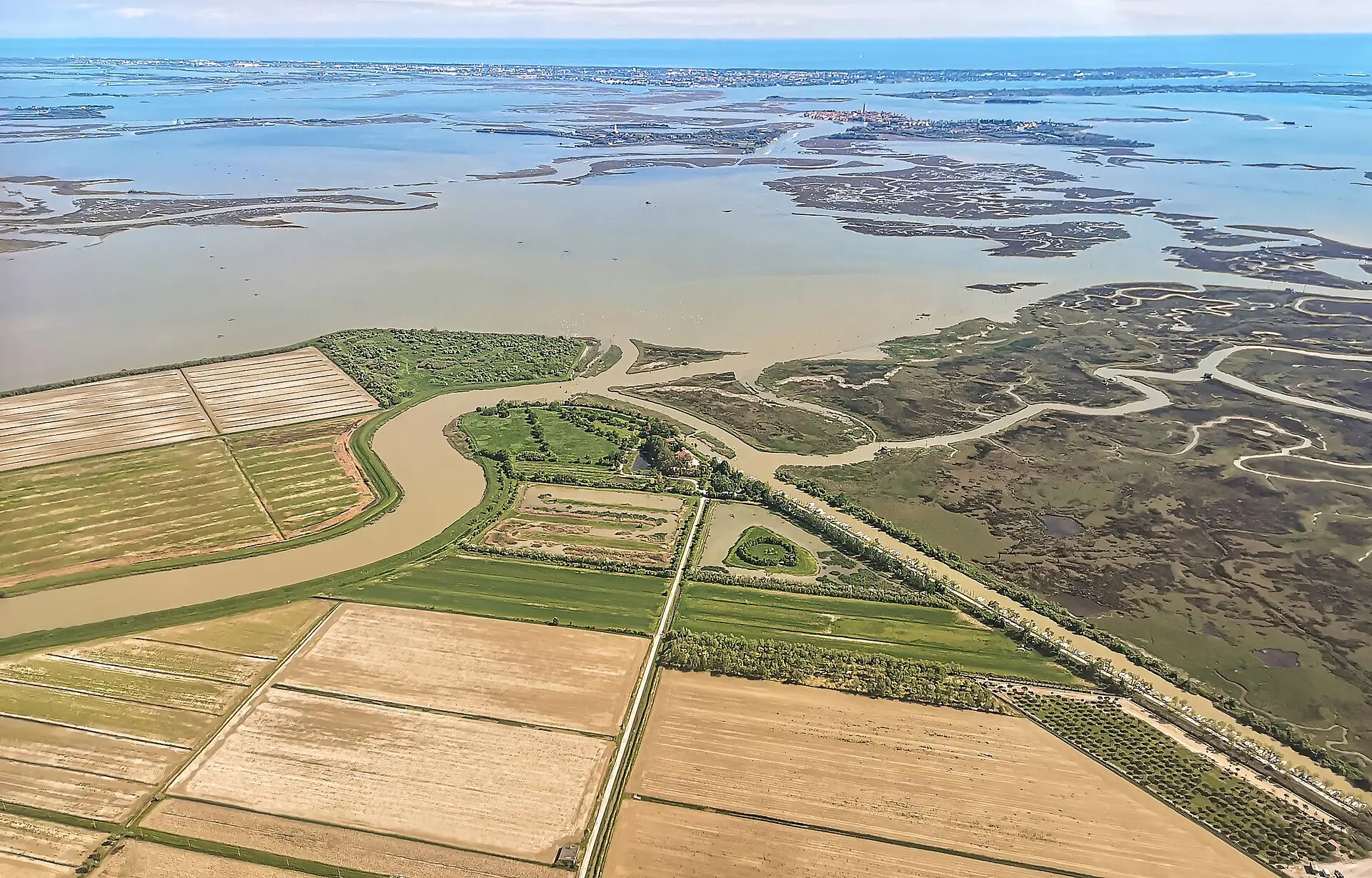
Historical sources include the State Archive of Venice’s description of Sabbadino’s 1553 map; Gelichi and colleagues’ archaeological study of San Lorenzo di Ammiana; Ca’ Foscari research on Costanziaco and remote sensing; and Rampazzo’s 2026 study of Ammiana. Featured photograph: Didier Descouens, Dese nella laguna di Venezia, CC BY-SA 4.0, via Wikimedia Commons. It shows the northern lagoon and remnants of islands, not an archaeological reconstruction.