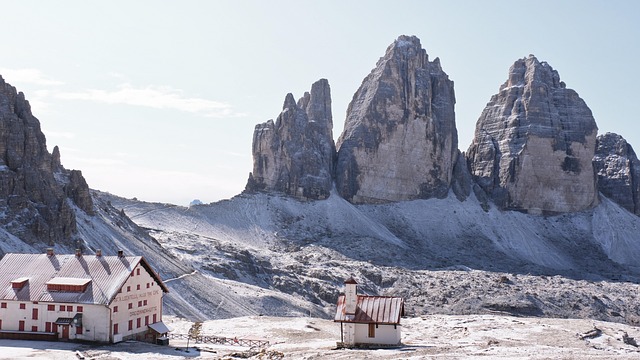
If a single image comes to mind when someone says “the Dolomites,” there’s a genuine chance it’s this one: three sheer, battlement-like limestone towers rising abruptly from an open alpine plateau, instantly recognizable even to people who’ve never set foot in Italy. The Tre Cime di Lavaredo, known in German as the Drei Zinnen, “three merlons,” aren’t just the most photographed peaks in the entire mountain range; they’re where much of modern Dolomite mountaineering itself was born, and where, a century ago, they briefly became one of the most brutal high-altitude battlefields of the First World War.
Three Towers, Two Hundred Million Years in the Making
The Tre Cime consist of three closely spaced summits, named from east to west: Cima Piccola, the “Little Peak,” at 2,857 meters; Cima Grande, the “Big Peak,” the tallest and most central of the three, at 2,999 meters; and Cima Ovest, the “Western Peak,” at 2,973 meters. Rising almost like colossal stone fingers from a base of loose scree, the three towers sit in the Sexten Dolomites, along the border between the Veneto region and South Tyrol, close enough to the Austrian frontier that the peaks themselves once marked the actual political boundary between Italy and Austria, before shifting territorial lines after the First World War left them instead straddling the internal border between the provinces of Belluno and South Tyrol, and, notably, the linguistic boundary between Italian and German-speaking communities that persists in this area today.
Their formation traces back more than 200 million years, to a period when this entire stretch of what’s now northeastern Italy sat submerged beneath a warm, shallow tropical sea, teeming with coral and marine organisms whose accumulated remains gradually transformed into dolomite, the pale, distinctively colored rock that gives the whole mountain range its name. Millions of years of subsequent glacial and atmospheric erosion sculpted that raw material into the isolated, sheer-walled towers visible today, carving away the surrounding rock and leaving the three peaks standing apart from the wider massif, their profile shifting dramatically depending on the angle from which you view them.
The Birth of Modern Dolomite Mountaineering
The Tre Cime’s mountaineering history begins with a single, genuinely pivotal figure: Paul Grohmann, a Vienna-born explorer who first glimpsed the Dolomites from the neighboring Tauern ranges and spent the years between 1863 and 1869 systematically climbing nearly every major peak in the range, effectively opening the entire Dolomites to modern mountaineering in the process. On August 21, 1869, Grohmann, accompanied by his guides Franz Innerkofler and Peter Salcher, achieved the first ascent of Cima Grande via its south face, a genuinely historic climb that transformed the previously mysterious towers into one of the most coveted mountaineering objectives in the entire Alps.
The remaining two peaks followed over the next several years, each carrying its own small, satisfying historical detail. Cima Ovest was first climbed exactly ten years later, on August 21, 1879, by Michel Innerkofler together with a tourist named G. Ploner. Cima Piccola, the smallest of the three but, remarkably, the most technically demanding of the original routes, wasn’t conquered until July 25, 1881, by Michel and Hans Innerkofler. All three original routes remain, to this day, the standard normal ascent lines still used by climbers attempting the peaks by their easiest paths.
Mountaineering on the Tre Cime kept evolving well into the 20th century. In 1913, the climber Hans Dülfer, considered by many the finest climber of the pre-World War era, opened a genuinely groundbreaking route on Cima Grande’s west face, introducing free-climbing techniques that marked a decisive shift away from the more mechanical, artificial climbing methods common at the time. Two decades later, the Tre Cime became the setting for one of the most celebrated achievements of the Dolomites’ legendary “Sixth Grade” era: on August 12 to 14, 1933, the climber Emilio Comici, together with Giuseppe and Angelo Dimai, completed the first ascent of Cima Grande’s north face, a nearly 500-meter, almost perfectly vertical wall long believed genuinely unclimbable, an achievement that carried enormous symbolic weight across the entire European climbing world at the time. Comici returned in 1937 to solo the same route entirely unroped, a feat that only reinforced his reputation as one of the defining climbers of his generation. Today, Rifugio Locatelli, known in German as the Dreizinnenhütte, sits on the peaks’ northern side and has served for over a century as the traditional gathering point for climbers attempting the celebrated north face routes.
A Battlefield Between 1915 and 1917
The Tre Cime’s dramatic isolation, which had made them such a coveted mountaineering prize, also made them a genuinely strategic position once war arrived in the Dolomites. Between 1915 and 1917, during the First World War, the peaks formed part of the frontline separating Austro-Hungarian forces on the northern side from Italian forces to the south, and the fighting that followed left a permanent mark on the surrounding landscape. Trenches, tunnels, equipped mountain paths, and military barracks were carved directly into the terrain across the massif and the neighboring Monte Paterno, and substantial remains of these wartime fortifications are still visible today for anyone hiking the area with an eye for the region’s more recent, harder history layered beneath its natural drama. Even the road that today carries visitors up toward the peaks from the southern side traces its origins to this same conflict, originally built by army engineers as a supply route for troops stationed along the front.
Part of the Dolomites’ UNESCO World Heritage Site
The Tre Cime and the surrounding high plateau, stretching north from the peaks toward the town of Toblach in South Tyrol, fall within what’s now the Tre Cime Nature Park (known until 2010 as the Sesto Dolomites Nature Park), and the entire area has formed part of the Dolomites’ UNESCO World Heritage listing since its 2009 inscription, recognized for the same exceptional geological and aesthetic qualities that first drew Paul Grohmann and his contemporaries here more than 150 years ago.
Visiting the Tre Cime Today
Most visitors reach the Tre Cime via a toll road climbing roughly seven kilometers from Lake Misurina up to Rifugio Auronzo, sitting at 2,320 meters and functioning as the primary staging point for nearly every visit to the peaks, whether hiking or climbing. The toll runs somewhere around thirty euros for a car, including parking, and the road is generally open from mid-June through late October, depending on snow conditions each year.
From Rifugio Auronzo, the classic Tre Cime circuit, sometimes called the Giro delle Tre Cime, loops around the base of all three towers across roughly nine and a half to ten kilometers, passing the small Zinnenseen lakes, patches of wild rhododendron, a working alpine dairy farm often serving fresh milk to passing hikers, and, depending on the season, wildflowers including the region’s distinctive yellow alpine poppies growing improbably out of the rocky terrain. It remains, without much competition, the single most popular and most rewarding day hike anywhere in the Dolomites, typically taking three to four hours at a comfortable pace. For hikers specifically interested in the area’s WWI history, a trail leading toward Rifugio Locatelli on the peaks’ northern side offers direct access to preserved trench systems alongside sweeping views of the celebrated north faces above.
Winter transforms the experience entirely: the ascent to the Tre Cime from Misurina becomes a genuine ski mountaineering classic, rewarding experienced, properly equipped ski tourers with spectacular views and a level of solitude the summer crowds simply don’t allow, though it demands real technical preparation, proper equipment, and a careful check of avalanche conditions before setting out.
Plan your visit: Tour of the Dolomites: A Journey Through Italy’s Most Breathtaking Mountains includes views of the Tre Cime di Lavaredo as part of a full day trip from Venice via Lake Misurina, and our helicopter tours over the Dolomites offer a genuinely dramatic aerial view of the three towers from above, a perspective that captures their isolated, battlement-like profile in a way ground-level touring simply can’t match.
Frequently Asked Questions
How tall are the Tre Cime di Lavaredo, and which is the tallest?
Cima Grande, the central peak, is the tallest at 2,999 meters, flanked by Cima Ovest at 2,973 meters and Cima Piccola at 2,857 meters. All three were first climbed between 1869 and 1881, with Cima Grande’s south face ascended first by Paul Grohmann in 1869.
Were the Tre Cime di Lavaredo part of a WWI battlefield?
Yes. Between 1915 and 1917, the peaks formed part of the frontline between Austro-Hungarian and Italian forces, and substantial remains of wartime trenches, tunnels, and fortifications are still visible today across the massif and the neighboring Monte Paterno, including along hiking trails near Rifugio Locatelli.
How do I get to the Tre Cime, and how long does the classic hike take?
How do I get to the Tre Cime, and how long does the classic hike take? Most visitors drive the toll road from Lake Misurina up to Rifugio Auronzo (2,320 meters), open roughly mid-June through late October. From there, the classic Tre Cime circuit loops around the base of all three peaks over about 9.5 to 10 kilometers, typically taking three to four hours at a comfortable pace.
How tall are the Tre Cime di Lavaredo, and which is the tallest?
Cima Grande, the central peak, is the tallest at 2,999 meters, flanked by Cima Ovest at 2,973 meters and Cima Piccola at 2,857 meters. All three were first climbed between 1869 and 1881, with Cima Grande’s south face ascended first by Paul Grohmann in 1869.
Were the Tre Cime di Lavaredo part of a WWI battlefield?
Yes. Between 1915 and 1917, the peaks formed part of the frontline between Austro-Hungarian and Italian forces, and substantial remains of wartime trenches, tunnels, and fortifications are still visible today across the massif and the neighboring Monte Paterno, including along hiking trails near Rifugio Locatelli.