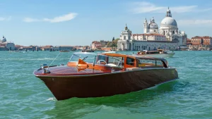
Everyone gets lost in Venice.
Not occasionally. Not if you’re directionally challenged. Everyone, repeatedly, throughout every visit. I’ve lived here for 28 years and I still sometimes find myself disoriented in neighborhoods I thought I knew, staring at my phone trying to understand how I ended up three streets away from where I intended to be.
Getting lost in Venice is inevitable. What’s not inevitable is the anxiety, frustration, and wasted time that getting lost creates.
The difference between tourists who enjoy getting lost (because they’ve accepted it as part of Venice experience) and tourists who hate getting lost (because they’re fighting it constantly) isn’t navigation skill. It’s understanding how Venice’s geography actually works, having practical strategies for reorienting when disoriented, and accepting that the city’s medieval street layout actively resists the grid-based navigation that most modern cities make automatic.
After 28 years navigating Venice daily — and watching tens of thousands of first-time visitors struggle with the same navigation challenges — I know exactly which strategies actually work versus which sound good but fail in practice.
This is the honest navigation guide. Not romantic nonsense about “wandering aimlessly through atmospheric streets.” Not complex orientation techniques requiring compass skills you don’t have. Just practical, proven methods that allow navigating Venice with confidence rather than constant stress.
Understanding how to approach Venice changes everything about the experience.
Why Venice Makes Navigation Impossible
Before learning strategies, understanding why Venice is so disorienting prevents the self-blame that makes getting lost emotionally exhausting.
Venice has no grid system. No numbered avenues running north-south, no lettered streets running east-west. The city developed organically over centuries on 118 small islands connected by bridges. Streets follow island contours and historical paths rather than rational planning.
The canals that most cities would use as orientation landmarks actually make navigation harder. They force circuitous routes around water, create dead ends, and prevent the straight-line thinking that grid cities allow.
Streets change names constantly. A single continuous pathway might have four different names along its length. You’ll be walking on Calle Larga XXII Marzo, which becomes Calle delle Ostreghe, which becomes Calle Seconda de la Fava — all without turning, simply by continuing straight.
This naming system made sense when neighborhoods were separate communities and locals knew every street intimately. For visitors trying to navigate using maps, it creates constant confusion about whether you’re on the right street or whether you’ve somehow turned without realizing it.
The addresses are insane. Rather than street-based numbering, Venice assigns numbers by sestiere (neighborhood). An address might be “Cannaregio 3456” — meaning somewhere in Cannaregio sestiere with no indication of which street, which campo, or which direction from any landmark.
Buildings aren’t numbered sequentially down streets. The numbers snake through the entire sestiere in patterns that made sense to 18th-century administrators but which provide zero navigational help to contemporary visitors.
The vertical dimension confuses everything. Venice is three-dimensional in ways flat maps don’t communicate. Bridges rise and fall constantly. Underpasses connect at different levels. What looks like continuous street might require going up and over a bridge or down through a sotoportego (covered passageway) that maps don’t clearly indicate.
Modern GPS helps somewhat but struggles with Venice’s density and verticality. The blue dot shows you’re “here” — but which floor? Which side of the canal? GPS says your destination is 50 meters away, but those 50 meters might require circuitous route involving three bridges and doubling back because direct path is blocked by water.
These aren’t problems you’re experiencing because you’re bad at navigation. They’re inherent features of a medieval city that was never designed for people who don’t live here permanently.
Understanding this removes the emotional weight. You’re not failing. The city is genuinely, systematically difficult to navigate. Even locals get disoriented occasionally.
The Yellow Signs: Your Primary Navigation Tool
Throughout Venice, yellow rectangular signs with black text point directions to major landmarks: “Per Rialto” (toward Rialto), “Per San Marco” (toward San Marco), “Per Ferrovia” (toward train station), “Per Piazzale Roma” (toward car/bus terminal).
These signs are your primary navigation infrastructure. Not GPS. Not paper maps. The yellow signs that appear at virtually every intersection throughout the city.
How to actually use them:
Identify your destination or the major landmark nearest your destination. If you’re trying to reach a restaurant in Dorsoduro, determine whether it’s closer to San Marco, Rialto, or Accademia. Once you know the major landmark, follow yellow signs pointing that direction.
The signs won’t take you to exact addresses. They’ll get you to major landmarks. From there, you’ll need additional navigation (asking locals, GPS for final blocks, or accepting that wandering the immediate area eventually reveals your destination).
The signs work because they create flow. You’re not trying to maintain perfect orientation or mentally map your position. You’re simply following directional indicators that accumulate toward correct general area. When you reach the landmark, you’re close enough that finding specific addresses becomes manageable.
The limitations matter too. Signs sometimes conflict or point in seemingly wrong directions. They guide toward landmarks through pedestrian-friendly routes rather than shortest distance. And in some neighborhoods — particularly residential areas away from tourist zones — the signs become sparse or absent entirely.
But for navigating between Venice’s major areas, the yellow signs work better than any other system. Use them first, GPS second, paper maps third.
The Big Three Landmarks: Your Mental Anchors
Venice navigation improves dramatically once you internalize three major landmarks that create mental triangle allowing rough orientation anywhere in the city.
San Marco (east-southeast): Venice’s most famous square and the Basilica. If you can determine which direction is San Marco, you know you’re oriented toward Venice’s tourist and historical heart.
Rialto (center): The Rialto Bridge and market area. This sits roughly in Venice’s geographic center, making it natural midpoint between other landmarks.
Train Station/Ferrovia (northwest): Santa Lucia train station. Knowing which direction is the station tells you which direction is mainland Venice and the city’s western edge.
Using the triangle for orientation:
When you’re disoriented, identify which of these three landmarks is closest. The yellow signs point toward them. Once you reach any of the three, you’ve established position on your mental map of Venice.
Standing at Rialto, you know San Marco is roughly southeast, the train station is roughly northwest. Standing at San Marco, Rialto is northwest, the train station is far northwest. These rough directional relationships allow navigation between areas even when you don’t know exact streets.
Secondary landmarks supplement the big three:
Piazzale Roma (car/bus terminal, western edge near train station) Accademia (bridge and gallery, southern Venice connecting Dorsoduro to San Marco) Fondamenta Nove (northern waterfront, vaporetto stop for lagoon islands)
Learning these secondary landmarks creates additional mental anchors. But start with the big three — San Marco, Rialto, Train Station. These provide enough orientation to navigate Venice’s main tourist areas confidently.
How to Use Your Phone Without Looking Like Tourist
GPS on smartphones helps Venice navigation significantly — but only if you understand its limitations and use it strategically rather than blindly.
Google Maps generally works well in Venice. The blue dot shows your location. The route suggestions mostly work (though they sometimes suggest paths that don’t account for bridges, stairs, or pedestrian restrictions). The search function finds addresses, restaurants, and landmarks.
But Venice’s density creates GPS challenges:
The blue dot might be accurate to within 5-10 meters — which sounds precise until you realize that puts you on one side of a canal or the other, which might require a 200-meter detour to the nearest bridge to actually reach.
Buildings block GPS signals. Walking under covered arcades or through sotoporteghi (covered passages) can cause the blue dot to jump erratically or lag behind your actual position.
The three-dimensional geography confuses GPS. The map shows you’re at a location, but you might be on a bridge above it, in an underpass below it, or on the opposite side of a building with no direct path.
Strategic GPS use:
Use GPS to confirm general direction and rough distance to destination. Don’t follow turn-by-turn navigation blindly — cross-reference with yellow signs and visible landmarks.
When GPS suggests a route, look at the map view to understand the path rather than just following voice prompts. If the route crosses multiple canals, prepare for bridges. If it goes through dense building areas, expect narrow passages and possible dead ends.
Use GPS most heavily for the final approach to specific addresses. Once you’re in the correct general area (achieved through yellow signs or landmark navigation), GPS becomes useful for pinpointing exact buildings.
Download offline maps before arriving. Venice has good WiFi in many areas, but connections can be spotty in residential neighborhoods. Offline Google Maps allows GPS navigation without data connection.
The phone-handling issue: Constantly staring at your phone while walking marks you as tourist and makes you target for pickpockets. Learn to check your phone quickly at intersections or when stationary rather than walking with phone permanently in hand.
What to Do When You’re Completely Lost
Despite all navigation strategies, you will become completely disoriented at some point. This is what to actually do when it happens.
Stop walking. The instinct when lost is to keep moving, hoping the next turn will clarify things. This usually makes things worse. Stop. Orient. Then move deliberately rather than wandering in panic.
Look for yellow signs. Even if you don’t know where you are, the signs point toward major landmarks. Pick one and follow signs toward it. You might not know your current position, but you’ll know your position once you reach Rialto or San Marco.
Look for water. Finding a canal or the lagoon shoreline provides orientation. Canals have names (usually marked on buildings at intersections). The lagoon shoreline tells you which edge of Venice you’ve reached. Water features create geography you can reference on maps.
Ask locals. Venetians are accustomed to disoriented tourists and generally helpful with directions. Asking for the nearest vaporetto stop often works better than asking for specific addresses — locals might not know every restaurant or shop, but they know which vaporetto stop is closest.
Use landmarks you can see. Church bell towers are visible from distance. The Campanile in San Marco is particularly useful — if you can see it, you know which direction San Marco is. Other church towers throughout Venice provide similar orientation once you learn to recognize them.
Head downhill toward water. Venice’s topography generally slopes toward canals. If you’re completely lost and can’t find signs or landmarks, walking downhill usually leads to canal, which provides the water-based orientation mentioned above.
Accept temporary defeat and take vaporetto. If you’re genuinely lost and frustrated, finding any vaporetto stop and taking the boat to a major stop you recognize (San Marco, Rialto, train station) resets your position. This “wastes” time and possibly money, but it ends the stress and puts you somewhere you can reorient properly.
What NOT to do: Don’t ask other tourists for directions. They’re as lost as you are, and following their confident-but-wrong guidance makes things worse. Don’t assume you can “power through” by continuing to walk without any orientation strategy — this burns time and energy while potentially moving you farther from your destination.
Understanding the Sestieri: Venice’s Six Neighborhoods
Venice divides into six neighborhoods called sestieri (singular: sestiere). Understanding these provides mental framework that aids navigation significantly.
San Marco: The tourist heart. Contains the Piazza, Basilica, Doge’s Palace, and most famous landmarks. If you’re near overwhelming tourist crowds and obvious luxury hotels, you’re in San Marco.
Castello: Venice’s largest sestiere, stretching east from San Marco toward the Arsenal and Sant’Elena. Western Castello maintains tourist presence. Eastern Castello becomes genuinely residential. If neighborhoods are getting quieter and more residential as you walk east from San Marco, you’re entering Castello.
Cannaregio: North of the Grand Canal, running from the train station eastward. Contains the Jewish Ghetto and many residential neighborhoods. If you’ve crossed the Grand Canal heading north and you’re not in obvious tourist zones, you’re likely in Cannaregio.
San Polo: Small sestiere containing the Rialto Market and numerous churches. The area between Rialto Bridge and the Frari church is San Polo territory. If you’re near the market or in densely packed residential streets between Rialto and the train station, you’re probably in San Polo.
Santa Croce: Venice’s most anonymous sestiere. Contains Piazzale Roma (car/bus terminal) at its western edge, otherwise fairly residential. If you’re near Piazzale Roma or in neighborhoods that feel residential without being particularly beautiful or touristy, you might be in Santa Croce.
Dorsoduro: Southern Venice, containing the Accademia, Peggy Guggenheim Collection, and many cultural institutions. If you’ve crossed the Accademia Bridge heading south or you’re near waterfront areas with good museums, you’re in Dorsoduro.
Understanding which sestiere fits your interests helps navigation because each has distinct character. When disoriented, determining which sestiere you’re in provides rough position that narrows possibilities significantly.
The practical use: Maps and guides often reference sestieri. Understanding “that restaurant is in Dorsoduro near Campo Santa Margherita” gives you rough location (southern Venice) and specific campo to aim for. This sestiere-then-campo framework works better than trying to navigate by street names that change constantly.
The Campo Strategy: Navigate From Square to Square
Venice’s campos (squares) provide natural navigation waypoints more useful than street names.
Every neighborhood contains multiple campos — open squares surrounded by buildings where multiple streets converge. These function as neighborhood centers, social gathering points, and natural landmarks.
The larger campos have names everyone knows: Campo Santa Margherita (Dorsoduro), Campo Santa Maria Formosa (Castello), Campo San Polo (San Polo). Learning these major campos creates mental map of Venice organized around open spaces rather than confusing streets.
Navigation using campos:
Identify which campo is nearest your destination. Navigate to that campo using yellow signs, landmarks, or GPS. Once you reach the campo, finding specific addresses in the surrounding streets becomes much simpler — you’re in a defined area rather than somewhere vague within a massive sestiere.
Campos serve as rest points. When navigating long distances across Venice, moving from campo to campo with breaks between allows pacing yourself rather than exhausting endless walking through narrow streets.
Campos often contain cafés, restaurants, or shops where you can ask directions. The businesses around major campos serve locals and tourists, meaning staff typically speak English and know the immediate area well.
The major campos you should learn:
- San Marco (obviously, though technically it’s piazza not campo)
- Rialto area (technically not a campo but functions as major gathering point)
- Campo Santa Margherita (Dorsoduro — university students, bars, social hub)
- Campo Santa Maria Formosa (Castello — beautiful, functional, central)
- Campo San Polo (San Polo — large, historic, residential feel)
- Campo San Giacomo dell’Orio (Santa Croce/San Polo border — medieval, lovely)
- Campo Santo Stefano (San Marco — elegant, less overwhelmed than the Piazza itself)
Learning to recognize these campos by sight — the architecture, the feel, the surrounding buildings — provides automatic orientation. “I’m in Campo Santa Margherita, therefore I’m in Dorsoduro, therefore San Marco is southeast, therefore I can navigate from here.”
Bridges as Navigation Landmarks
Venice has roughly 400 bridges. Most are small and anonymous. But the major bridges provide crucial orientation landmarks.
The Four Grand Canal Bridges:
Ponte di Rialto (Rialto Bridge) — Venice’s most famous bridge, connecting San Marco to San Polo. Stone arch, shops on both sides, impossible to miss. If you’re crossing this bridge, you’re crossing the Grand Canal at Venice’s midpoint.
Ponte dell’Accademia (Accademia Bridge) — Wooden bridge connecting San Marco to Dorsoduro. If you cross this heading south, you’re entering Dorsoduro. The Accademia Gallery sits at the southern end.
Ponte degli Scalzi (Station Bridge) — Near the train station, connecting Lista di Spagna to the station itself. Crossing this bridge means you’re at Venice’s western edge near the station.
Ponte della Costituzione (Constitution Bridge/Calatrava Bridge) — Modern bridge connecting Piazzale Roma to the train station. Controversial modern architecture, completed 2008. If you’re crossing this, you’re between Venice’s two mainland connection points.
Why these bridges matter for navigation:
They’re the only Grand Canal crossings. Knowing which bridge you’re near tells you exactly where you are relative to the Grand Canal — which runs through Venice like major spine dividing the city.
The bridges are large enough and distinctive enough that GPS shows them clearly. When disoriented, finding a Grand Canal bridge and identifying which one provides instant position confirmation.
Other notable bridges:
Ponte delle Guglie (Cannaregio) — crosses Cannaregio Canal near the Ghetto Ponte dei Sospiri (Bridge of Sighs) — connects Doge’s Palace to prisons, though this is viewing landmark rather than crossing point Ponte delle Tette (literally “Bridge of Tits”) — San Polo, historically where prostitutes displayed themselves, now simply named bridge near San Cassiano
Learning to recognize the Grand Canal bridges on sight — Rialto’s stone arch, Accademia’s wooden construction, Scalzi’s position near the station — provides orientation that street names simply can’t match.
Using the Vaporetto System for Position Reset
Venice’s water bus system (vaporetto) provides more than transportation. It’s navigation tool that allows resetting your position when lost.
Line 1 travels the entire Grand Canal. From Piazzale Roma at the western edge to San Marco and beyond to Lido. Boarding Line 1 at any point and riding it provides continuous Grand Canal views that help understand Venice’s geography.
More practically, boarding any vaporetto and riding to a major stop you recognize (Rialto, San Marco, train station) instantly transports you from “completely lost” to “at known landmark.” This costs a vaporetto ticket but saves potentially hours of frustrated wandering.
A multi-day vaporetto pass removes the cost calculation. With unlimited travel pass, using vaporetti for position reset becomes free navigation tool rather than expensive bailout.
The vaporetto stops themselves serve as landmarks. Major stops like Rialto, Accademia, San Zaccaria (near San Marco), Ca’ d’Oro, Salute — these are named after nearby landmarks and appear on all Venice maps. Finding a vaporetto stop and reading its name provides instant position confirmation.
Strategic vaporetto use for navigation:
When planning routes between distant Venice areas, consider vaporetto rather than walking. The boat might take longer but removes navigation stress entirely. The route is fixed, the stops are announced, and you can’t get lost on a boat.
Use Line 1 deliberately for geographic orientation. Riding the full route from Piazzale Roma to San Marco shows how Venice’s geography actually works — the Grand Canal’s S-curve, the major landmarks in sequence, the relationship between areas that walking through narrow streets obscures.
Late in the day when you’re tired and disoriented, vaporetto provides low-effort return to hotel or central landmark. The mental cost of navigation when exhausted is higher than the time or money cost of taking the boat.
What a First-Day Orientation Tour Actually Provides
The single most effective navigation investment is professional orientation tour on your first Venice day — not to see landmarks but to understand geography.
A good orientation tour teaches you:
How the sestieri relate to each other spatially. Which direction is San Marco from Rialto. Where Dorsoduro sits relative to Cannaregio. This mental map aids all subsequent navigation.
Which landmarks are visible from distance and how to use them for orientation. The Campanile in San Marco. Major church towers throughout the city. The Rialto Bridge’s profile from various angles.
How to read the yellow signs and use campo-to-campo navigation. Which major campos matter most and how they connect.
Where the major vaporetto stops are and how to use water buses strategically for both transport and position reset.
A private orientation tour delivers maximum value because it customizes to your specific accommodation location and planned activities. The guide shows you navigation relevant to where you’re actually staying and where you actually plan to go rather than generic city overview.
The tour also provides guide’s phone number or contact information for the rest of your stay. When you inevitably get lost despite all learned strategies, being able to text photo of your location and ask “where am I and how do I get to X?” provides bailout option that reduces navigation anxiety significantly.
The orientation tour should happen on arrival day or first full day. Everything else you do in Venice — independent exploration, museum visits, restaurant finding — becomes easier and less stressful when you understand basic navigation before attempting it.
The cost is modest relative to total trip expense and the value in reduced stress, saved time, and improved confidence navigating independently is enormous.
Accepting That Getting Lost Is Actually Fine
The final navigation “strategy” is psychological rather than tactical: accepting that getting lost in Venice is not just inevitable but often valuable.
Some of Venice’s best discoveries happen when lost. The restaurants you find by accident in residential neighborhoods. The quiet campos where locals gather. The churches holding beautiful art that you’d never visit if you maintained perfect route efficiency.
Venice rewards wandering without agenda. The rigid itinerary attempting perfect navigation to predetermined stops misses the serendipitous beauty that makes Venice genuinely memorable.
The psychological shift required:
Getting lost is not failure. It’s inherent Venice experience that locals accept and visitors should too.
Being disoriented doesn’t mean you’re wasting time. Unless you have rigid schedule requiring presence at specific location at specific time, wandering “lost” through beautiful city is exactly what you came to Venice to do.
The anxiety about getting lost often causes more stress than the actual disorientation. If you’ve allocated buffer time, if you’re not rushing to catch trains or make reservations, if you’re simply exploring — then being temporarily lost creates zero actual problems despite potentially creating significant anxiety.
Practical manifestation:
Build extra time into all navigation estimates. If GPS says 15-minute walk, allocate 25-30 minutes. The buffer removes pressure and allows getting lost without consequences.
Make reservations flexible or avoid time-specific commitments early in your visit before you’ve learned basic navigation. Dinner reservations at rigid time create stress. Knowing you’ll “eat somewhere around 7-8 PM” provides flexibility that getting lost can’t disrupt.
Distinguish between good lost (wandering interesting areas, discovering new spaces, experiencing Venice beyond tourist zones) and bad lost (late for important commitment, in uninteresting area, feeling unsafe, genuinely unable to find major landmark despite effort). The first is valuable. The second requires using the strategies above to reorient efficiently.
Venice is fundamentally a wandering city. The navigation strategies help you wander productively rather than stress inefficiently. But perfect navigation that eliminates all wrong turns also eliminates the discovery that makes Venice special.
The balance: learn enough navigation to avoid bad lost while maintaining enough flexibility to embrace good lost.
Plan Your Confident Venice Navigation
For first-day orientation: A private walking tour teaching navigation strategies, geographic relationships, and Venice-specific orientation techniques transforms the entire visit from stressful navigation to confident exploration.
For water transport strategy: A vaporetto pass provides navigation bailout option and position-reset capability that removes anxiety about getting lost. Unlimited water bus travel means using boats strategically rather than only when absolutely necessary.
For neighborhood understanding: Which sestiere fits your style helps you understand where you actually want to spend time, making navigation purposeful rather than random wandering hoping you’ll accidentally find interesting areas.
For three-day planning: A structured itinerary that accounts for navigation learning curve — easier navigation on day one while learning, more ambitious independent exploration days two and three once basic orientation is established.
For accepting good lost: Venice without a checklist means building enough navigation confidence to wander productively while maintaining enough structure to avoid wasting time on genuinely frustrating disorientation.
Learn Venice Navigation from Someone Who Still Gets Lost After 28 Years (But Knows Exactly How to Handle It)
After nearly three decades navigating Venice daily and being featured by Rick Steves, NBC, and US Today, I know exactly which navigation strategies actually work versus which sound good but fail in practice. Getting lost is inevitable. Stress about getting lost is optional. The difference is understanding how Venice’s geography actually works and having practical tools for reorienting when disoriented. Let me teach you navigation strategies that make Venice accessible rather than overwhelming — not perfect efficiency but confident exploration.
Book a first-day orientation tour or secure a vaporetto pass for navigation flexibility — transform Venice from confusing maze into navigable city.
Frequently Asked Questions
Can I actually navigate Venice without smartphone GPS?
Yes, though it’s harder than it was before smartphones existed and easier than some traditionalists claim. The yellow signs pointing to major landmarks work excellently for getting between main areas. Paper maps help if you actually study them before walking rather than trying to read them while moving. The key is accepting that navigation without GPS means slower, more deliberate movement with more frequent stops to confirm orientation. It also means increased likelihood of wrong turns — which might be frustrating or might lead to interesting discoveries depending on your schedule and temperament. GPS is enormously helpful convenience rather than absolute necessity. But depending entirely on GPS means never learning the campo-to-campo, landmark-based navigation that locals use and which works even when technology fails.
Is it safe to walk around Venice when lost and disoriented?
Yes, Venice is remarkably safe city even in areas that feel isolated or unfamiliar. Violent crime is extremely rare. The tight-knit social fabric means residential neighborhoods have natural surveillance — people notice unfamiliar faces but this creates safety rather than threat. The main risks when disoriented are: minor theft from pickpockets if you’re obviously distracted and carrying valuables visibly, and exhaustion from walking much longer distances than intended if you’re physically limited or traveling with young children. But genuine physical danger from being lost in Venice is essentially nonexistent. The worst outcome of being lost is wasted time and frustration, not actual safety threat. This contrasts sharply with many cities where wrong neighborhood means genuine risk.
What should I do if I’m lost and my phone battery dies?
First, don’t panic — this is annoying but not catastrophic. Find a café, restaurant, or shop and ask to charge your phone briefly. Most Venetian businesses accommodate this, particularly if you buy something small. While charging (even 10-15 minutes provides enough battery for basic GPS), ask staff for directions to nearest major landmark. If charging isn’t available, use yellow signs to navigate to Rialto, San Marco, or the train station — any of these puts you somewhere you can fully reorient. If you’re completely lost and can’t find signs, head downhill toward water, find a canal, and follow it until you reach area with more foot traffic and visible landmarks. The density of Venice’s tourist infrastructure means you’re never more than 10-15 minutes’ walk from major landmark even if you’re completely disoriented. Worst case: find any vaporetto stop, board boat heading toward Rialto or San Marco, and reset position from there. The situation is inconvenient but solvable without technology.